From The Sea Canoeist, September
1998
The Girl and I, and Albatross Island.
May 2-6, 1998
Scribe: Laurie Ford
Sue had a bit of time on her hands, plus a brand new shiny sea kayak,
and wanted to do something serious with it. She’d been staying with Cec
and I while we made a few minor modifications to the kayak,
and made a sail and other fittings, in line with the way most Maatsuyker
kayaks are fitted out. Sue also tried her hand at making a fibreglass paddle
on an aluminium shaft, with a couple of 'go-fast’ stripes on
each blade.
I personally like the Hunter Island/Three Hummock Island area for first
trips - as it gives an excellent idea of what sea canoeing is all about.
The area does have fast tides, and can get windy and rough, but has
plenty of lovely islands and beaches. Probably not a place for ‘shrinking
violets’.
The tides weren't actually ideal the week we went - in fact it was high
tide at 5.00 am, and 5.40 pm on the day we were to leave. So we rose at
4.00 am on Saturday morning, after camping at the end of the
road at Robbins Passage. Sunrise was not till 7.00 am.
4.45 am saw two dim shapes slip away from the shoreline, on a calm but
overcast night. The gloom was punctuated by brief intermittent red flashes
as our lights winked on and off - one tied across Sue’s
front deck, and one built into my hat. The Wallaby Islands were an
indistinct blur in the distance, but it wasn't long before we glided past
them, and turned north to head for Walker Island. Now and again our
paddles and rudders scraped the bottom and we made further out to the
west each time to get further away from the shoreline - dimly perceived
a kilometre or so to the east. This area dries out at low tide,
and isn't all that deep at high tide - and this adds interest to navigating
and timing, even in the daylight. Flocks of swans took to the air as our
passage disturbed them, providing the only noise in the still of the
night.
Two hours later the sky started to lighten and we were able to get an
idea of exactly where we were - a few kilometres off the entrance to Mosquito
Inlet. Now a very light westerly let us put sails up as we
continued to glide towards the top of Walker Island - where we landed
at 7.30 am for a break after our 20 km night excursion. We switched the
‘flashers’ off, inspected the nearby mutton birders’ huts in the
early dawn, then re-embarked as it was much warmer in the kayaks than
out.
Conditions were perfect to point the kayaks towards South Hummock hill,
12 km away on Three Hummock Island. We cruised across in the warming day,
occasionally getting enough wind for a brief sail,
and then having to put them away as the wind dropped again. Under South
Hummock we turned right and followed the orange lichen-covered granite
shoreline round to East Telegraph Beach. The tidal
current aided this stretch of paddling, and even though we landed on
the beach after a 36 km paddle - it seemed all too easy - it was still
only 11.00 am. East Telegraph Beach is a glorious place in good
weather, as it was now - miles of sunlit sandy beach with not another
single soul in sight. The tide was well out, and this was Sue’s first go
at carrying her fully loaded kayak any distance - but we managed, by
stopping and changing hands halfway. Then it was into dry clothes and
an hours rest for lunch before setting out on the 6 km walk to the top
of South Hummock. East Telegraph Beach is not the greatest
place to camp, and most people usually camp at the top of the beach
on the dry sand. We only camp here because this is where the track up to
the airfield starts, and then on to South Hummock. The first
three km is along a 4WD track through thick scrub, and is fairly easy
going - the next three (from the airfield) is along a well made gravel
road which climbs steadily all the way to the 237m peak.
The peak used to have a Telecom radio tower on it which was a landmark
from 50 km away - but this is now lying on the ground in a state of dis-assembly
as the island reverts to Nature Reserve status. The
day was still clear and sunny, and we got a good view of the surrounding
islands - and could see the inlet where we had paddled in the dark was
now almost completely dry. A couple of fishing boats near
Middle Bank were mere dots, and we decided that sea kayaks would be
very difficult to spot from up here.
Back on the beach we set up camp and scoured the beach in both directions
for driftwood for the fire, the temperature dropping noticeably when the
sun dipped behind the island. We sat round the fire into
the night, enjoying the spectacle of a completely clear sky - swapping
amusing incidents from family life. I used to think I came from a slightly
unusual family, but not anymore - Sue can beat me hands down.
Due to wanting to travel with tidal assistance we were on the water
by 7.00 am the next morning, packing our dew laden tents away while it
was still dark. It was yet 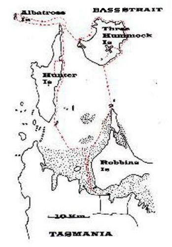 another
glorious warm sunny calm day and we took our time as we followed the shoreline
north and then west around to a beach we call Five Sisters Beach - because
of the five big granite monoliths standing in a line at the western end
of the beach, where we camp. Sue immediately went for a swim after we hauled
the kayaks up the beach at 11.00 am - still with half the day to explore
the island. Warwick spotted us walking across his paddocks and raced up
to investigate, but was quickly at ease when he saw it was me again, back
for yet another visit. I was here in February with Phil and Ian, hoping
to visit Albatross Island - but thwarted by unseasonal strong winds day
after day.
another
glorious warm sunny calm day and we took our time as we followed the shoreline
north and then west around to a beach we call Five Sisters Beach - because
of the five big granite monoliths standing in a line at the western end
of the beach, where we camp. Sue immediately went for a swim after we hauled
the kayaks up the beach at 11.00 am - still with half the day to explore
the island. Warwick spotted us walking across his paddocks and raced up
to investigate, but was quickly at ease when he saw it was me again, back
for yet another visit. I was here in February with Phil and Ian, hoping
to visit Albatross Island - but thwarted by unseasonal strong winds day
after day.
Sue and I inspected the yacht moored at the old stone jetty in front
of the original weather board homestead. The homestead, jetty, and yacht
have all seen better days, but no doubt there are years of life left in
them yet. Back at our beach I dozed in the sun while Sue set off round
to the next beach. Having visited this place many times before I didn't
feel like traipsing all over the place, not at my age - I’ll leave that
for youngsters like Sue.
The afternoon was a brilliant day to dry out the wet tents and flys,
and canoeing gear - and we topped it off with another camp fire on the
beach. This time we had a much better place for the tents, up the hill
on flat grassy sites in amongst some small tussocks.
During these first two days Sue said she hoped it wasn't going to be
all flat calm - she wanted a bit of ‘real’ weather. Day three we had originally
scheduled just to go 7 km across Hope Channel to Shepherds Bay to camp,
but Albatross Island was just 17 km away. If the weather held could we
go out and back? Sue had yet to have any practice in surf at all - had
never braced into a wave of any size. Just by sheer coincidence nearly
every time she has been out paddling it has been pretty calm, so naturally
she is still a bit nervous about the thought of breaking seas. But how
could we be so near and pass up the possibility - the number of sea canoeists
that have landed on Albatross Island can be counted on two hands, and to
my knowledge the number of female sea canoeists can be counted on one finger.
The forecast for strengthening easterly winds didn't deter us as we
set off at 7.00 am, but the seas off the end of Hunter Island were intimidating
for a beginner. There were patches of breaking 2 metre seas, thrown up
by the fast currents meeting at Cape Keraudren - the long narrow finger
of land that points northward. I thought that if Sue actually copped a
breaking wave she’d be a goner - but we snuck through this minefield of
whitewater unscathed, the water churning and boiling around us. Once round
the point the sea smoothed out to nothing and we quickly raised sail and
pointed the bows towards the long grey lump of rocky island 12 km to the
west. Now that the clear skies of the last two days had lured us out into
the open it clouded over, and we neared the island in cold miserable conditions,
with the seas starting to increase. We could feel the big ocean swells
coming up from the south west meeting the waves being generated by the
easterly wind, which waxed and waned, and then freshened some more.
I’d aimed to get to the island about slack water, but the tide and wind
had combined to cut an hour off my estimation, and as we closed to within
a hundred metres of the sheer rocky cliffs we felt the tide
streaming down the side against us. The seas was now quite chaotic
with the waves rebounding off the cliffs, and after 20 minutes our progress
along the island towards the landing gulch on the northern end
was a big fat zero. We were barely holding our own, let alone making
any headway. Sue called me back to point out this lack of progress, and
I told her we just had to go a bit harder - just to the end of the
island - it was only 1.2 km long.
We both tried a bit harder, and this time after half an hour you could
see we’d gained 100 metres or so - but getting tired doing so. The tide
should have been slowing down but it wasn't all that obvious for a
while, and it took about an hour to paddle the length of the island.
Halfway along Sue called out again, and suggested that if we weren't likely
to be able to land then maybe we should give up before we
became exhausted. Secretly I had already decided I was going to have
a determined go at landing if it even looked only slightly possible, and
felt that in the tiny gulch it would be OK. Finally we reached the
end of the island, and were immediately in relatively smoother water
- away from the backwash off the cliffs. I nearly went past the gulch,
and had to call Sue back - and suspect she must have thought that it
didn't look a very inviting place. The small swell was breaking around
the point, but then flattening out in the last few metres - the gulch is
only about 30 metre long, and offers minimal protection from the seas.
I made my run in over a bit of a kelp bed, still keeping an eye back
over my shoulder to my youngish companion - and Oh horrors - there she
was upside down. Turning round in the middle of the thick kelp
was frustrating as my paddle tangled at every stroke, but I eventually
got back out to her and assisted her back into the cockpit, and we tried
again. Soon we were lifting up and down with the swell, watching
for a moment to jump over the side and try to scramble up the steep
sharp rocks. I picked the wrong moment and spent the next minute or so
being swept almost out of reach of the shore, then back in again,
then out again. The thick kelp gave me something to hold on to and
I was able to lift and slide the Sea Leopard up the rocks and into a cleft
where it wouldn't slide back into the water again. Then it was
Sue’s turn to come alongside, and I grabbed her bow and exhorted her
to jump out quickly - and we hauled her Greenlander onto firm land - finally.
The fine misty rain made for a lightning fast change into dry
clothes before we set off up the gully to the first cave, which runs
through the centre of the island. In my haste I slipped and fell very heavily,
almost disappearing down a big hole between the boulders, and
Sue had a momentary vision of being stuck on the island with a serious
fracture case on her hands. It was just luck that she wasn't.
The albatross rookery still had a large number of birds in it - I hadn't
been at all sure that there would still be birds around so long after the
nesting season. On closer inspection they were mainly immature
birds, with a lot of black on their necks and heads, but full grown
- and some were still perching on the round saucer shaped mud nests. There
were a very large number of dead birds all around - as though
the parents had stopped feeding the young before they could properly
fend for themselves. We quickly checked out both parts of the rookery,
took a few photos, and then were driven to seek shelter inside
the cave as the bleak rain increased, and the temperature dropped.
I now had a bit of a dilemma, to go or to stay. It was 20 km back to
Shepherds Bay, the first 12 against the freshening easterly wind, but with
tide assistance diagonally across our path. The other option was
to camp for the night and hope that tomorrow would be better. This
was unlikely as the wind was probably going to go round to the north before
a change that was predicted, and a northerly would blow
straight into the gulch making it impossible to leave for days. 1.00
pm was the deadline to leave, to get as much help from the tide as possible.
We spent some time walking up and down the inside the cave
attempting to warm up, and watching the heavy rain across the entrance,
before dashing down to the kayaks for another lightning fast change into
dripping wet paddling gear.
We launched Sue’s kayak, and again I was swept off my feet as I attempted
to hold it steady for her to embark. Then I launched myself without incident
and we were both safely afloat again, clear of the
island. Visibility was only a few km in the rain, and for half an hour
or so I steered a compass course in the direction of Cape Keraudren. The
seas were bigger now, but not breaking, and the wind didn't
seem to impede us all that much. We were half way across after an hour,
and starting to get glimpses of Hunter Island through the misty rain. As
we neared the cape I could see a huge area of breakers off the
point, and thought that we were going to be in for a very interesting
time to say the least. But the closer we came the more the current was
slowing down, and just as we entered the area the whitecaps more
or less disappeared, and just left 3 to 4 metre steep standing waves.
Sue was quite a way off to my left as we rounded the point, and I watched
her as she tended to round up into some of the bigger ones -
going in the opposite direction to where we needed to go. She said
later on that as she was battling through this area she was looking up
above her head, and thinking, ‘These waves are as big as my house’.
But she eventually got past and into smoother water behind the cape,
and then turned and headed down to where I was sitting and watching. We
had a drink, and a bite of chocolate and muesli bars, then
took up the paddles again to head slowly down the coast towards Shepherds
Bay. The tide turned against us about now, and we needed some hard paddling
to get past the narrowest part of the channel
between Three Hummock and Hunter Islands. There really aren't any places
to land along this bit of coast, all rocks and no beach, and we went slower
and slower. We’d been on the water at 7.00 am, and
landed at Shepherds Bay about 5.00 pm, a 10 hour day. Take off the
couple of hours we had on Albatross Island, and that leaves an 8 hour paddling
day - in some intimidating seas. It’s no wonder that when the bow of her
kayak slid onto the beach, she just sat there and said, ‘I’m knackered’.
Halfway down the island I’d told her we’d be having a rest day at Shepherds
Bay, and so we did. It was almost dark as we landed, and we quickly set
up camp and got a small fire going while we had tea -
then off to bed before 7.00 pm.
The following day was cold and overcast and showery again, and after
a 10 km walk along the 4WD track towards the homestead and back we both
retired to our sleeping bags in the middle of the day and
slept for a while. The afternoon cleared and we gathered firewood for
the night, and sat out under a clearing sky till 9.00 pm.
The last day I initially planned to paddle slowly down the coast of
Hunter Island to Stack Island, and then wait till 5.00 pm before heading
across back to the vehicle in the dark, and arrive at high water.
However, it was a glorious day as we sailed before a light NE wind
all the way down the more interesting part of Hunter Island - with numerous
lovely beaches interspersed with small rocky headlands. We
cruised past Cave Bay, just enjoying an easy day in the sunshine. The
forecast was for a cold 25 to 30 knot SW change during the afternoon and
I decided this wouldn't be much fun after dark, and told Sue
we’d keep going - even though it meant arriving back at the car at
dead low tide, and a probable 400 to 500 metre portage across the sand
banks. If we could find the right channel, that was!
We stopped briefly on Stack Island to have a snack, and don more thermals
before the cold change swept in. Then it was off towards Kangaroo Island
in light winds and calm conditions, still sailing along
with minimum paddling required. I picked the wrong channel initially,
and when we ran out of water had to stand up on a sand bank and look around
for a better channel, and then we used our ‘leads’ to pull
the kayaks through the shallow water, and over sand banks for about
400 metres. It was just like taking the dog for a walk. The next channel
was good and deep, and we followed it easily for a while, as it
was marked with sticks along the side. However, this led us to a complete
dead end - a two foot high sand bank across our path. By now the change
had arrived and it was damn cold scurrying around over
the sandbanks on foot in the rain, seeking a deeper channel to get
us closer to the car. We found one a long way away, and had to paddle back
the way we’d come for a distance, then found a ‘new’ channel
marked with floating black plastic drums I’d never seen before. This
led in the desired direction, and we sailed along in shallow water with
the wind increasing, and the cold driving rain, and found the closest
we could get to the car was about 400 metres.
We made a few trips across the wet sand - Sue carried most of the gear
out of both kayaks, and the paddles, and I carried the nearly empty kayaks
one at a time. Just on dark we were loaded up and on our
way into Smithton, and then to Sisters Beach - a warm house, and ‘real’
food.
This was one of the most enjoyable trips I have ever done in this area,
partly because of the charming company, and partly because of the real
delight that Sue obviously felt in paddling in such an interesting
and challenging area - and full credit to her for taking it on with
such little experience.
Return to Laurie's Trips