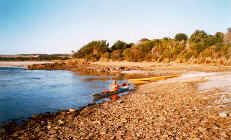 The
start at Little Musselroe Bay.
The
start at Little Musselroe Bay.
Monday, February 23, 2004
Little Musselroe to Preservation
Island 33
km, 4hr
45min
(Map)
Huge swells and rambunctious water for the crossing!!! No
surprise,
really, as there had been very strong westerlies throughout Tassie for
four days, even gusting to 135 km/hr on the Friday (so we learned from
the man in the fire tower on Mt Horror near Bridport on Sunday).
The
start at Little Musselroe Bay.
We started at 8:00 a.m. right on low tide and with a SW 15 knot wind. Sailed the first hour and just as I was deciding the wind was getting too erratic for me I capsized! Laurie came back to assist and then I kept the sail stowed until less boisterous water within an hour of Preservation Island. Those swells out in the Strait truly seemed like mountains – about 5 meters high. I was on top of a swell and looking down on Laurie in the trough and it was like looking down a crevass. What an exhilarating ride! If Laurie had been alone he could have sailed all the way and set a record – he had been thinking of putting his second sail up just as I decided to put mine away. Every now and then a rougher patch of water maybe half a km square would loom up in front of us and we would bear away to go round it, and were lucky that during the entire crossing neither of us were ever caught by the huge breaking waves.
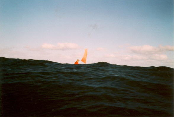
About an hour after the start, just before the wind increased and Elli swam.
Towards the end we noticed the tide was sweeping us towards Cape Sir John, and possibly along the outside of Preservation Island. But by now we were getting into shallow, more settled conditions, and were able to put a sail back up and run off before the wind to make sure of being inside the island.
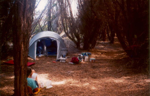
We spent an extremely comfortable night on the island. Found that the waterproof camera got water in it on today's crossing, so we only have photos of the very start of this trip.
Tuesday, February 24
Preservation to Badger
Island 46km, 7hr
Bruised a rib in my wet exit yesterday and today I realized that I would need plenty of aspirin to keep paddling!
Left at 8:15 a.m. and arrived at Goose Island at 12:30, using two sails from Long Island in a light NE breeze and rising tide. Beached at a 10 metre wide cove just north of the lighthouse and walked around the newly painted white tower. Sat on rocks to eat my crackers and apple and then, at 1:30, headed into the wind and waves over to camp on Badger Island, going along the north end through the channel between Chappell Island, coming ashore at 4:30 on the NE shore at the north end of the beach which has the old jetty.
Strong NE wind so we set up camp in the lee of thick bushes on the point by the new jetty. Took a walk to see the new bunkhouse/lodge owned by the Aboriginals and then on to the old homestead area. We passed piles of new fence posts and rolls of new wire fencing. The island is one of three transferred to the Aboriginals, though Alf Stackhouse still has the agricultural lease.
After tea we were leaning against a fallen tree, relaxing out of the wind, when we happened to turn our heads. There behind us - a metre away - was a young Tasmanian Devil studying us He was a very healthy looking specimum. A sea eagle flew into the flat top of a macrocarpa tree for the night. Two wallabies approached cautiously in the dusky light. A thin moon slid in and out of gray clouds. Great to be back in the islands!
Wednesday, February 25
Badger to Chappell
Island 5.5km, 1hr 10min
I swore I would never go to Chappell Island, “the snake island”. But Laurie said “Trust me, they won’t chase you!” and off we went, leaving at 7:00 into strong NE wind and waves.
Ashore at a wide white beach/sandspit just south of a landing area on Chappell where there are sheds and a sheep chute. We changed into dry clothes with long pants tucked into socks. Took Laurie’s paddle apart so that we each had a walking stick/weapon and headed off up the ridge. Saw four black Tiger snakes on the way up; two big, two smaller. They were all fairly sluggish and certainly weren’t interested in chasing me. It wasn’t terrible!
We stood up on the trig framework at the top to look over the great views (Goose Island looked so small) and then wandered down the west side of the hill and around the south end to check out another new building. (This island also now belongs to the Aboriginals). With the wind strengthening we decided to stay on Chappell and have an easy day.
We swept out one of the sheds (near the sandspit), which had bunks and a bench. Moved a mattress from another shed. Slept and read. A water tank there had water.
Thursday, February 26
Chappell Island to Trousers Point (Flinders
Island)
10km, 1hr 30min
The 5:55 weather report said NE 8knot winds so we decided to be on our way. Coke and aspirins and on the water at 6:45. Seemed quite a bit stronger than 8 knots! We were treated to an absolutely beautiful sunrise as we came across – the kind with fiery gold rims to the clouds and streaming rays.
Just before reaching Trousers Point Laurie spotted two kayaks sailing towards us from the north. He paddled back out to say hello and found that they were Ian Souter from Victoria and Dick Condon from Queensland who were en route from Wilson’s Prom to Little Musselroe where their wives would meet them. They went to Kindergarten together and were doing a Bass Strait crossing to celebrate their 60th birthdays! They had come through 40knot winds between Deal and Killiecrankie.
As I came into the beach I found three kayaks – what a lot of kayak traffic in one day! These kayakers were Rick Boyle, Allan Lee and John ? from Tassie who had come out on the ferry from Bridport on Monday for a two-week paddle among the islands. They were just packing up to head off north.
During the afternoon two sailing boats came in to anchor in the bay, one from Sydney, one from Hobart.
Trousers Point campground has a toilet block, picnic tables, fire rings, and a water tank.
Friday, February 27
Trousers Point to Allport’s
Beach 38km, 5hr 40min
We started paddling at 5:50 a.m. and got to Whitemark at 7:50. We went to the bakery first for pies (opens at 7:00) and then the IGA (open M-F, 9-5:30 and Sat, 9-12:30).
A woman at Bowman’s Store in Whitemark told us that Tasmanian Devils were introduced to Badger Island about 6 years ago. They eat Cape Barren Geese eggs (now that they have cleaned up the sheep carcasses) and are considered a problem by Parks and Wildlife.
Left again at 9:50 and had two sails up in light NE wind out to Long Point, getting there on the rising tide when the endless jagged rocks would be fairly well covered. Then two hours paddling across Arthur Bay. Around Settlement Point one hour after high tide with almost no wind and then just a lazy sail to Allport’s Beach, arriving about 1:30. Again, there are toilet block, picnic tables, fire rings and water tank.
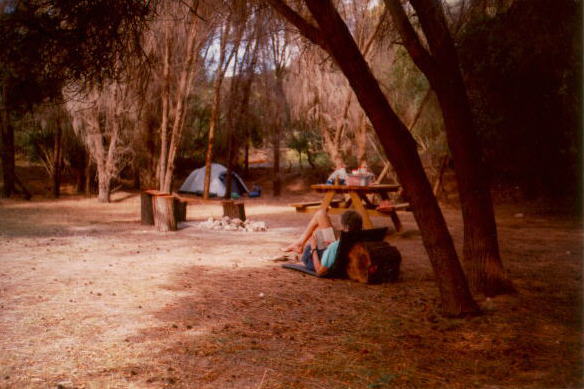
We could see from footprints on the beach that Rick, John and Allan had recently left and, from one of the higher rocks, we could just see them along the far beach mid-way around the bay. We briefly contemplated continuing on to camp with them but ended up pitching camp on Dr Allport’s 1930s era tennis court – a flat, shaded area with fire ring and picnic table 100m down the road. Snoozed and read. This tennis court now has trees growing in the center of it, and provides one of the better campsites in the Furneaux group of islands.
Camped on the 'tennis court' at Allports Beach.
Saturday, February 28
Allport’s Beach
I wanted to see the Emita Museum (open weekends 1-5) again (we visited it during our trip here two years ago) so we decided to stay over another night and relax. At the museum we enjoyed talking with the day’s volunteer, Jude, from Killiecrankie, where she has started a grove with 1200 young olive trees. We looked at the displays. There are binders filled with information and photos on every possible subject.
Big flocks of currawong birds passed through the trees around the tennis court, croaking noisily to each other, several times during the day…luckily not at night.
Sunday, February 29
Allport’s Beach
Wild water today out in the bay. Very strong wind. We decided to walk to Castle Rock (6.5k), and read instead of paddling on.
Monday, March 1
Allport’s Beach to
Killiecrankie
30.5km, 4hr
Yesterday’s wild water was all tame and placid this morning. Got under way at 7:47 a.m. to cross to Cape Frankland. Both sails up trying to catch the light NE breeze to help with the paddling. Some confused water and big swells at the Cape at fullest flow of outgoing tide. Coming into Killiecrankie is so deceptive as the store, homes, olive groves etc are not visible. It’s such a beautiful bay.
A horseback rider and dog were coming along the beach. It was Jude who said that Rick, Allan and John had left earlier in the morning going north.
The one store is open 7 days, 9-5 but in reality is only open when owner Allan Wheatley happens to be around. It has limited groceries, no take out food or pies now, a freezer of ice creams, tourist items. Jude runs the campground at $2/person. You need to light the chip heater if you want a hot water shower at the toilet block. We chose to camp on Alf's lawn just above the end of the beach - although Alf was away in Launceston.
Tuesday, March 2
Killiecrankie to Marshall Bay 22km, 3hr
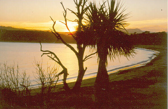 Killiecrankie
Bay early in the morning.
Killiecrankie
Bay early in the morning.
A lazy morning waiting until the tide would be right to sweep us on the return trip around Cape Frankland. On the water at 11:00 with nice NE wind and no swells. Sailing along the shoreline looking at rocks and coves – my idea of heaven!
The treat of the trip happened between the Cape and Roydon Island when seven dolphins crossed our path. Laurie said they’d play if you interact so he turned and followed them. Soon I could see them surfacing around his boat and eventually, when he turned to come back towards me, they came too! They continued on with us a couple of kms until we turned in to shore. It was like choreography as they escorted us along, surfacing on both sides and in front, passing under the boat with their white bellies up, playing along with us. It was magic when four simultaneously arched out of the water right next to the bow of my kayak.
Around the point into Marshall Bay we got strong NE winds till we found a flat area to camp above a beach. This was at someone’s personal picnic area with BBQ, old tables, and plastic chairs among the tea trees. Took a walk and collected firewood, then enjoyed the lovely view across to Prime Seal Island and Settlement Point.
Wednesday, March 3
Marshall Bay to Whitemark
39km, 4hr
On the water at 7:40 and a good sail in NE wind across to Settlement Point in 1hr40. After the point we hugged the shoreline and rocks to avoid the wind and beached at Lillie’s Beach (picnic table and toilet but no water) to wait for the wind to go more northerly before continuing on. We were also waiting for the tide to rise because the paddle across from Long Point to Whitemark is a real drag in shallow water.
I walked the 3km to Wybaleena chapel and cemetery to see that historic site again and later watched large juvenile gulls on the beach pestering their mothers by continually squeaking, and rubbing the underside of her throat. If I were a seagull mom I would throw up my feathers over such demanding offspring.
At 4:40 decided the wind was now more northerly and paddled/sailed to Long Point and on into Whitemark, taking 2hr15. Landed at the swimming float where the toilet block and changing shelter are. Kids were happily sailing a homemade raft. Changed into dry clothes and headed to the pub for cider and a meal. Set up our tent among the trees at the top of the foreshore lawn.
Thursday, March 4
Whitemark to Big Dog
Island 37km, 5hr
To the bakery for pies and when I asked if they would fill our water bottles were told “not allowed by law, you’ll have to buy water at the store”. We filled our water at the toilet block near our tent where the sign says 'not for drinking', then went to the Council Office and asked what was wrong with the water. It’s just got tannin in it and needs to be boiled. We only use water for my tea or for soup so no worries. (We drink coke). To the IGA for groceries…a couple of cans of stew, cup of soups, biscuits, chocolate and coke.
No wind today but we did ride the outgoing tide all the way and it was a delightful day. Two hours to the point just past Trousers. Gazed down into clear deep water. We could see the new road that has been put through to Lady Barron round the southern end of Flinders Island.
We started getting into the very shallow water around Big Dog and even got out to walk and pull our boats as we came into a bay to see about camping on the flat lawn near a shack. A woman came to tell us that it was in use by people doing mutton-bird research. They pull the chicks from the burrows to weigh, measure, band and replace them. The project has been going on for 15 years, she said.
Back in our boats and around a point to land at a better sandy beach with a mutton-birders' shack and brand new processing building. Big Dog is another island that has become Aboriginal owned and we saw half a dozen identical new processing buildings, with cool rooms. Requirements have changed to necessitate better hygiene and refrigeration.
Laurie worked on stopping some of the leaks in his vintage Sea Leopard (25 years old), which he recently re-acquired. This was a good place to do the work with lumber lying around to use for saw horses and bits and pieces of plastic to fashion into a plug for the back mast step. Used water from the tank.
I enjoyed the beautiful view over a turquoise bay to Mt. Kerford and the hills on Cape Barren Island. So still at night that we could hear the whirr of each mutton-bird returning in the dark. Still taking plenty of aspirin.
Friday, March 5
Big Dog Island to Ned’s
Point 32km, 4hr
15min
The wind came up in the night and shook the tent! We took it down very early before any poles broke and sat in the open birders’ shed. Our intention had been to go down the east shore of Cape Barren Island with the predicted SW winds - but weather forecasts had changed.
We left at 7:00 on high water and paddled around the sheltered east end of Big Dog and then, with the outgoing tide, reached Lady Barron at 8:35. Talked with three fellows in a sailboat from Melbourne, went to the pub for ciders and chips, and then to the store (up hill and far from the docks!)
We waited for the tide change and at 3:25 let it carry us against a mild headwind to Ned’s Point on Cape Barren Island, arriving there at 6:05. This is one of my favorite campsites. We use an area where a homestead once stood below the huge macrocarpa trees. There’s a well-made fire circle and the big pinecones burn well. Views from the beach across to Strezlecki are spectacular.
Saturday, March 6
Ned’s Point to Rebecca
Bay 43km, 6hr
On the water at 8:00 enjoying the last of the rising tide and an ENE wind to sail along past The Corner. Noticed someone waving at the jetty and there were Rick, Allan and John. Allan held my boat from being washed onto the rocks while all talked about plans. They mentioned three other paddlers in the area. Then we were off again past Long Island and as the tide turned to ebb we went along that fun rocky coastline towards Thunder and Lightning Bay. Sails down and hard paddle into the strong wind to come into the Bay and beach by the usual camping area. We checked out the campsite, and looked at the fresh water still bubbling out of the sand and flowing across the beach - this is another one of the better campsites.
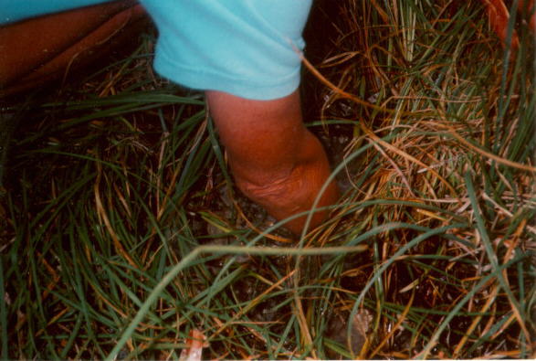
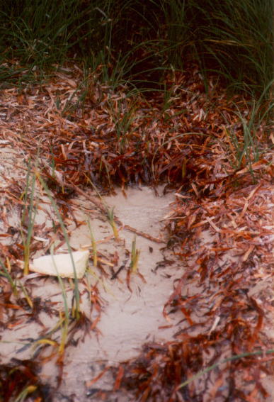
Thunder & Lightning Bay is one of the really
good campsites
in this area - particularly to sit out a few days of bad weather. Near
the top of the beach fresh water bubbles up out of deep holes. If you
can
then clean away the seagrass and dam the flow you have some very
excellent
drinking water. (Photos from a previous trip - we didn't camp here this
trip). This is also within walking distance of the store at 'The
Corner'
on Cape Barren Island.
Just too early to stop and camp so we carried on, luckily well inside the Bay. A very strong wind suddenly buffeted us from the side with spray streaming from the waves and howling confusion. Turning through by Key Island it was suddenly calm but then as we proceeded we realized this was not a good situation and that we should get ashore. So we abruptly turned to land at the first very small beach in a cove area. From here we could watch the whirlwinds of spray screaming across the bay and on out to sea - the wind was at least 35 knots.
Imagine our surprise to see fresh footprints there, to follow them, see the tracks where 3 kayaks had been pulled up and to find the still-warm coals of a campfire against a rock mid-beach! So few kayakers and so many beaches - this seemed like a small world!! We waited an hour, rekindling the fire and seeing a thin, foot-long black snake, which disappeared into the sand; and waited until the wind abated and then we continued on, still using the tidal current. It was easy sailing to Preservation Island where we hoped to camp.
The son of one of the 20 owners of Preservation Island was there with two mates and the wives, enjoying a weekend of fishing. Had a cup of tea with them and told them of our adventures before continuing on with the wind and tide to sail easily down to Rebecca Bay. We could easily see across Banks Strait to Cape Portland and conditions were so perfect to continue across that if there hadn’t been a build up of gray, lowering clouds we would have been tempted to go right on to Little Musselroe!
Once ashore at Rebecca we carried our camping gear up along the fence line several hundred metres to the excellent sheltered “rooms” camping area among the shrubs. There is 2 to 3 metre high scrub here, and a 3 metre wide 'track' meanders into it for about 100 metres - providing perfect shelter in any conditions.
Sunday, March 7
Rebecca Bay
Good to be in such a sheltered camp spot to wait out a day of strong southerly wind. No going across today! We walked to Lookout Head and watched a fishing boat bucking into the waves and swells. Near our tent Laurie watched a wallaby standing up and pulling branches of shrubs down to eat the little leaves.
Monday, March 8
Rebecca Bay to Little
Musselroe
22km, 4hr
Despite drizzle and mist decided the mild SE wind would be OK to cross the Strait and to leave by 10:00, two and a half hours before high tide. As we were packing our boats three paddlers came around the point into the beach! They were from Hobart and were indeed the ones who had been on that little beach with the campfire.
I showed them how to find the campsite and Laurie told them about crossing with the tide, heading magnetic south. Then we were off, at 10:35...being late, so we hoped the plan would still bring us spot on to our car! Easy waves and diminishing headwind. The whole way across we were engulfed in grayness, drizzle and fog and could see nothing of land untill we were level with Little Swan. Stopping for a drink halfway across Laurie turned right around and could see the other 3 kayakers about a km behind us. We could hear the surf before we saw land. By heading constantly to 180 degrees we came exactly to the entrance to Little Musselroe Bay. The three paddlers were soon along behind us, having to pull their boats against the out-flowing current as I had (Laurie was able to paddle against it right to the boat ramp).
Time then to chat together, to change into dry clothes, to unpack, load on the boats, talk with Liz Ponting and also the elderly gentleman who has had the first shack there for 44 years. Apparently there have been lots of paddlers with a group leaving the day before to head to Wilson’s Prom.
I decided this year that heading out to the Flinders Island once more would be the perfect way to celebrate my 65th birthday – and it was! There is little that equals the beauty of those mountainous islands and white beaches, the turquoise water, the wildlife, and the lazy rests between paddles. What a life!!