Banks Strait 2018 - Laurie Ford (Mac's report here.) (John's report here) (Roger Greenwood's report)
(The Debriefing trip)
39 trips across Banks Strait without ever the slightest
problem and I totally screwed up the 40th attempt by making the most
basic elementary mistake.
I’m sitting in front of my computer shaking my head, and
thinking “did I really do that?” But I did and I can’t think of any reason why,
other than I must have had a total mind block at the time. Ah well, worse thing
happen at sea.
I imagine I can hear the words “Senile”, and “Past his
use-by date” being bandied about – but no harm was done. We just didn’t get anywhere
we should have and had to return to the starting point – running before a bit
of a gale for several hours. Not only was I way off, I also went through a
whole comedy of errors during the night paddle.
I’ll try and run through the whole sequence of events.
I (78) was planning to paddle out to Flinders Island from Little
Musselroe Bay for 2 weeks with my friends John (65), Mac (63), and Toby (68). Toby had flown
down from Ballina in northern NSW especially for it.
Three Victorian paddlers – all that was left of the original
group of 5 who were going to paddle across Bass Strait decided to paddle with
us across Banks Strait. Roger was then going to paddle Bass Strait on his own
and Georgia and Tom in a double were just going to go out and back to Flinders
Island with us.
We all met at Little Musselroe Bay on Saturday the 24th
March and the forecast for the next few days was basically gales – but with a
small window of opportunity to get across to Spike Bay or Preservation Island
on Saturday night.
Now some years ago (2016) I left Little Musselroe Bay at low
water and paddled straight across to Spike Bay and then onto Trousers Point
without the slightest trouble with tidal currents. http://www.laurie-ford-kayak.net/Training%20Trip%20to%20Trousers%20Pt.html
In 2014 Sue and I had left Swan Island at low water and
paddled straight across to Spike Bay and then to Preservation Island, landing
there 3 ½ hours after leaving Swan Island without any problem with the
currents.
http://www.laurie-ford-kayak.net/Flinders%20Island%202014.html
So you can leave from
Little Musselroe Bay at low water (but it is better from the eastern end of
Swan Island) but only if the difference in the height of low and high water in
Bass Strait is low, ie as much under 2 metres as possible.
So for some unknown reason I thought we could leave Little
Musselroe Bay at 10.15pm (approx. an hour before low water) and do the same
thing, but I never even looked at the height of the tides. That was crazy.
For many years I’ve been explaining to paddlers the best way
of crossing Banks Strait – mainly by starting 2 hours before low water (or high
water) and heading north (or south) the whole time.
http://www.laurie-ford-kayak.net/Banks%20Strait%20N%20to%20S.html
Now if you read that you will see that I know damn well that
the difference between the height of low water and high water makes a huge
difference to the speed of the currents.
So why did I blithely not even look at the heights this time
– I can’t explain why I didn’t. Later on after the event I did have a look and the
difference was about 3 metres – ie maximum current. So we left before 10pm
after I made it clear to everyone that I would not entertain paddling with
anyone having a white light on their kayak. I threatened to smash Roger’s off
his kayak if he attempted to use it. It may be the law but the authorities are
not out here in the middle of Banks Strait on a wild night trying have good
night vision. We have been using red flashing lights for over 35 years, and in
fact Toby had one of the original ones that we home built 34 years ago before
LED bike lights were invented. He had it tied across his rear deck as well as a
bike flasher on his hat. Roger and the double managed to cover their white
lights with red material.
And if you look at the path of the Tracker it is fairly
obvious that the current took us a hell of a long way out to the west – a hell
of a long way. After 5 hours I realised that we had missed Clarke Island and
would probably have to paddle NE to get back towards the top of it and in the
direction of Preservation Island. Roger and Georgia turned their GPSs on and
found that we were miles away from anywhere and I heard “We have to paddle east
to get to Cape Barren Island; we have to paddle east to get to Cape Barren
Island.” They didn’t realise it was Clarke Island we were west of. I still
preferred to go NE. We had been paddling north the whole time.
It
was about now that a whole lot of comedy of errors happened to me.
First of all when we had paddled out of Little Musselroe Bay I
didn’t have my spray deck on as I thought we may have to get out and
drag the
kayaks over the small bar. We didn’t have to but I got a lot of water
in the
kayak so once out through the tiny waves I put the spray deck on and
turned the
electric pump on – and then forgot all about it. It runs fairly
silently and it
wasn’t till much later in the night when I had a bit of water in the
kayak that
I went to turn the pump on and found it was still on, and had flattened
the
battery.
I found that my thighs were getting extremely painful when I
was sitting upright and could only paddle when leaning back quite a bit. I had
my sail up in the very light wind and calm conditions and had let the paddle go
to reach forward to turn the torch on to illuminate the compass for a moment to
keep checking the direction and got caught by a gust of wind from the other
side of the sail – without the paddle in my hand to do a support stroke and
promptly capsized. Now that was extremely embarrassing – for Laurie Ford to
capsize in those conditions. The double came alongside and helped me back in – but
in pulling myself back into the cockpit I broke the fibreglass seal holding the
front of the cockpit rim so now had a leaky kayak. I had lost my sponge and a
bottle of Coke in the capsize so borrowed Toby’s sponge. It was slow but I
could feel the water getting lower – but not fast enough for the others and
Roger gave me his hand pump.
In the capsize my red flasher on my hat had stopped working
so I dropped it in the ocean and got a spare one out of my glovebox and put
that one. Later on (on shore) I discovered my waterproof digital camera was
also not working.
I think it was about here that a little bit of panic set in.
I was told by Roger to order Mac to accept a tow because he was slowing us down
and we needed to speed up or we would be out here all night. I told him Mac
didn’t need a tow and that I had no problem with being out all night. He said
that he’d been on the go for 30 hours and he didn’t want to be out there all
night.
Not long after that he departed from us, taking the double
with him, heading back to Little Musselroe Bay, after asking Mac and John and
Toby if they were going to go with him. They declined, so the 4 of us were left
to ourselves.
I take a bit of a dim view of this because as far as I am
concerned if you start paddling with a group you finish paddling with that
group. You should never have individuals all making their own decision and splitting
off in different directions.
We continued till it started to get light thinking we’d see
where we were but there was not a bit of land to be seen in any direction –
just low cloud all round. I was in great difficulty by now and was almost lying
along the back deck to be able to paddle at all – and now the forecast gale
started to make itself felt. The only option was to head SE back to Little
Musselroe Bay, directly downwind. Now I could put my small sail up and scoot
off without paddling. I was getting a lot of water in the kayak and every ten
or fifteen minutes would ease the sail out to let the others catch up, and take
the front corner of the spray deck off and sponge out with one hand. I was
getting it pretty dry every-time by the time the others caught up.
After an hour and a half of heading SE I felt we needed to
go south a bit more – we still couldn’t see land in any direction. The wind had
been increasing all this time and the seas building up and I was having one of
the best sailing experiences I’ve ever had. And there was an absolutely brilliant
display of lightning from a fairly close brief electrical storm – I wouldn’t
have missed that for anything. The thunder claps and rolls were great.
Finally directly ahead we could see the wind generators on
Cape Portland, and then could easily see a lot of beaches straight in front of
us. When we were closer and obviously all going to make shore I pulled the sail
down with a lot of difficulty because of the force of the wind. When they
caught up again I told Mac that there was no way I could get to shore without
sailing – my legs were getting a bit excruciating by now. He nodded and kept
going with John and Toby. Now I had a hell of a job to get the sail back up
again. I’d just get a cm or two of the mast in the hole when I would have to
let it go to do a support stroke and the sail and mast would blow into the
water. This happened three times, and my paddle went in as well once.
Finally I did get it up and away I went on a wild ride
towards the shore – terrific fun. I decided I wasn’t stopping anymore and would
let the water get higher in the cockpit and just go for it. There were many
beaches but the first few had big sand hills behind than and I was looking for
one with trees where we could camp in shelter. I had to get ashore and I
assumed the others would want to get ashore as soon as possible as well. These
beaches did all have surf on them. So I found one with trees and headed in and
surfed up on the beach with the sail up and the rudder down – and then found my
arms didn’t have the strength to lift me out of the cockpit. I had to lie along
the deck and push off the footrest to lie on the back deck and then rolled off
onto the wet sand. Got on my hands and knees and stood up and promptly fell over
flat on my back. I moved on hands and knees a couple of metres to my paddle and
used that to help me stand up – I was in bad shape. I was wet and in a strong
wind so staggered off along the beach to find a way up to where I thought I’d
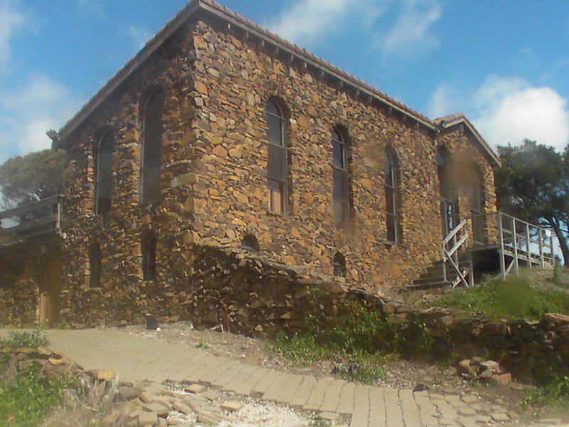
seen a building. There was a beautiful stone house there and I sat in shelter
for some time to recover a bit. I trekked back and forth along the beach a
hundred and fifty to two hundred metres to get dry clothes and tent fly and
sleeping and camping gear. I’d landed at 10am, pretty well exactly 12 hours
after launching from Little Musselroe Bay yesterday.
None of the others landed in here so I assumed (quite
wrongly as it turned out) that they just headed into the first beach to get
ashore as soon as they could. I struggled back along in that direction to check
out a couple of the beaches but then was too tired to go any further. I still
had the Tracker on as didn’t want to hit the OK button till I felt things were
OK. We’d been so close in that even if they had all capsized they would have
all ended up ashore so I turned the Tracker off – but still had a minor concern
over where they were.
Mac and Toby have paddled in much bigger seas than that for
a much longer period in 1987 when they did a double crossing of Bass Strait. The
strong wind warning we thought we would be paddling in from Deal Island to Flinders
Island had been upgraded to a Gale warning unbeknown to us.
http://www.laurie-ford-kayak.net/maatcm87.htm
But John had never been in anything like this and was in a
very unstable kayak, but I knew he had an excellent support stroke. My concern
was that he had dislocated his shoulder a few weeks ago and it was possible it
could happen again with a big support stroke. Later back in Hobart he told me
that he had it strapped by Matt before coming and that had probably helped a
lot to stop it coming out again.
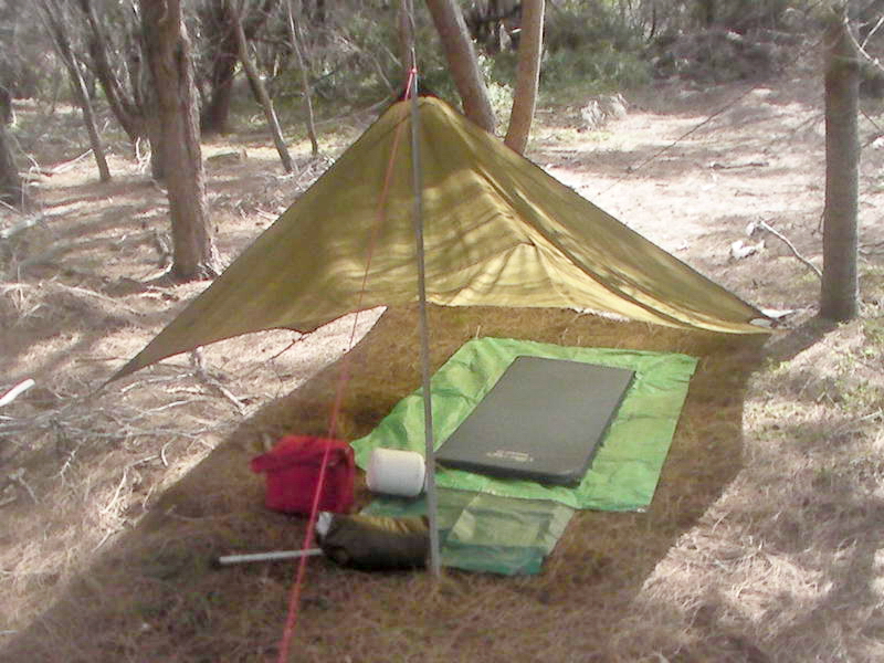
I settled in under my tent fly for the night, feeling pretty
well done in. The first high tide that day came right up to the Sea Leopard
so I moved it right to the back of the beach. The high tide the next morning came
almost right to there so I ended up putting it on top of the 2 metre bank – in the
bushes.
Unbeknown to me Toby had kept me in sight and saw the bay I
went into and came a little way into it but didn’t see me land. Then he saw Mac
and John out further heading towards the next point in the direction of Little
Musselroe Bay. He went out to follow them and shortly found John ashore on a
sheltered beach where there was no surf, and joined him ashore.
I’m hoping that John and Mac will write their own story shortly.
Mac's report. John was slightly ahead of Mac and it was very difficult to keep looking back to
see him. John remembered from previous trips that I had told him you need to keep
very close to shore off Cape Portland or you will be in danger of not being able
to reach the shore – and end up being swept out to Swan Island. So he kept very
close and landed on the first sheltered beach, and waved his sail so that Mac would
see him. Mac did but couldn’t get to this beach and landed on the next one. Toby
came round close inshore and landed with John.
Mac had been too far out to land on John’s beach so landed
on the next one. At the end of the road to Little Musselroe Bay there are steps
down to a small beach – Mac landed on the next beach just to the north of that,
and Toby and John were on the next one north. Mac did actually walk to Little Musselroe
Bay and then back to his kayak. Toby and John rested for an hour and then
paddled the last km or so to Little Musselroe Bay, gathering Mac on the way and
they all arrived together. Georgia told Mac the exact time they landed and Mac
and the others landed on their beaches only 15 minutes later – we had caught up
at least an hour and a half on them.
I had made it very clear to the Victorians when they first
turned up on Saturday that our policy is that if we get ourselves into trouble
WE will get ourselves out of trouble. In forty years of paddling – sometimes
extreme paddling, we have never had the occasion to involve the police.
Monday
morning I had recovered somewhat and went off to find
a hill where I could get phone reception – but intending to stay camped
where I
was till the weather was more suitable for continuing to Little
Musselroe Bay.
I got one bar on the phone and rang Sue (it was her Tracker) and told
her I’d
mislaid the others. She told me she’d had a text message from Toby
yesterday
and they were fine – so no problem – just a bit concerned over me. She
then
told me that Peter had rung the police at Georgia's request, but
then Georgia rang him again shortly after and told him to cancel it as Mac and Toby
and John had just arrived. Peter rang the police again and said all was
OK, which made the police very happy.
I had a bit of a chuckle over this as I had a mental picture
of a chopper setting down where I was camped and the police finding me
reclining under my tent fly listening to the radio and consuming an egg &
bacon pie with some coke and a conversation something like this:
“Are you Laurie Ford?”
“Yes.”
“We had a message that you were in trouble and needed
rescuing.”
“Whoever told you that you’d better take them to court and
charge them with making nuisance calls.”
So I was lying under the tent fly warm and cosy and dozing
when I heard “Laurie, Laurie” I couldn’t believe that anyone had found me but
it was Liz Ponting and Toby. Liz’s brother Dave comes out a few times a week to
open the visitors centre and he and Liz and Toby had a good look at the Tracker
plot and Liz said she’d drive to the beaches about where it showed I was. They
checked out a couple to the west of me before finding me. All this land is
owned by the Hydro and trespassers are forbidden but Liz worked on the Cape
Portland property and had keys to be able to get to some of the padlocks to
check on the cattle. She still had to inform the Hydro at the entrance what she
was doing.
So she drove me back to her place to get my vehicle, and
Roger asked if I needed a hand and came back with me to help Toby and I to carry
the still loaded kayak along the beach. Just before we arrived at the house my
left rear tyre went flat and we put the spare on. We just threw my gear into
the car and the loaded kayak on the roof rack and headed back past the Hydro
office to let them know we were leaving.
Liz Ponting is a good friend for doing all this and refused
any payment for her troubles.
Mac and John had gone home yesterday, and Georgia and Tom
had also left. Toby was still keen to continue to go to Flinders Island. The
weather wasn’t suitable for the next day or so and as I now didn’t have a spare
tyre I opted to drive to Scottsdale to get it repaired and consider our
options. We just made it 5 minutes before closing time and left it with the
tyre people and booked into a motel.
I wasn’t in any shape to continue the paddle right away, but
do usually recover fairly quickly from tiredness. But this leg problem was
something totally new and I was a bit unsure about it. I also would have to
repair the front of the cockpit. My pump battery had been recharged by my solar
panel while I’d been camped on my own. In the end I said I thought it would be
a little foolish of me to continue till I recovered really fully and investigated
my leg problem. Sue had said when I was talking to her that this is not
uncommon and is a back problem – by a bit of osteoporosis of the spine, L4 to
be exact.
I have found this online:
However,
with its heavy load and range of flexibility, the L4-L5 segment is also prone
to developing pain from injury and/or from degenerative changes, such as:
- The L4 vertebra can slip
forward over the L5 vertebra, impinging the nerve root and causing lower
back and/or leg pain (sciatica)
- The L4-L5 disc, in between
the L4 and L5 vertebrae, can herniate or degenerate, leading to possible
leg pain (sciatica) and/or lower back pain
- The two joints called facet joints
(or zygapophyseal joints), which connect to the L4 and L5 vertebrae in the
back of the spine, can allow abnormal amount of motion and/or develop
osteoarthritis
- The back of the L4-L5
segment has a nerve that passes through it, from inside the spinal canal
down through the back of each leg (as part of the sciatic nerve).
This nerve is called the L4 nerve root. If any in inflammatory proteins
from inside the disc herniate and come in contact with this nerve, or if
anything presses against it, pain can travel down the nerve (called a
radiculopathy, or sciatica).
Bugger.
Anyway Toby and I had a bit of a chuckle over the whole
event and the reaction of other people and he said he wouldn’t have missed it
for anything – but still disappointed we were not going to get to Flinders
Island.
The next morning we found the tyre was not repairable and
when I asked for a new one was told that he sold the last two yesterday. Toby
and I continued to Launceston and then Devonport where his Landrover was. He
only moved to NSW last year from Launceston and had to leave the Landrover for
later. He was going to take it on the ferry when he went back to NSW. I left him and continued
towards Burnie to call on a friend who had just had a quadruple bypass; and I was
pulled up for speeding through Wesley Vale – 74 in a 60 zone. I was certainly
having a “bad hair day”. The nice lady policewoman let me off with a caution
and then noticed my haggard condition and asked if I was alright. I told her I
was just having a bad day.
I stayed the night with a friend on a farm and he had a
spare wheel and tyre that didn’t fit either of his utes but did fit mine so I
then had a spare tyre for the 6 hour drive home.
I feel pretty bad about letting everyone down, particularly
Toby who had come a long way, and also Georgia and Tom. They had come with us
(the experts) to learn a bit about paddling in this area – sorry about that
kids. But at least it was a good learning curve and an excellent demonstration
of the tides in this area – an excellent demonstration.
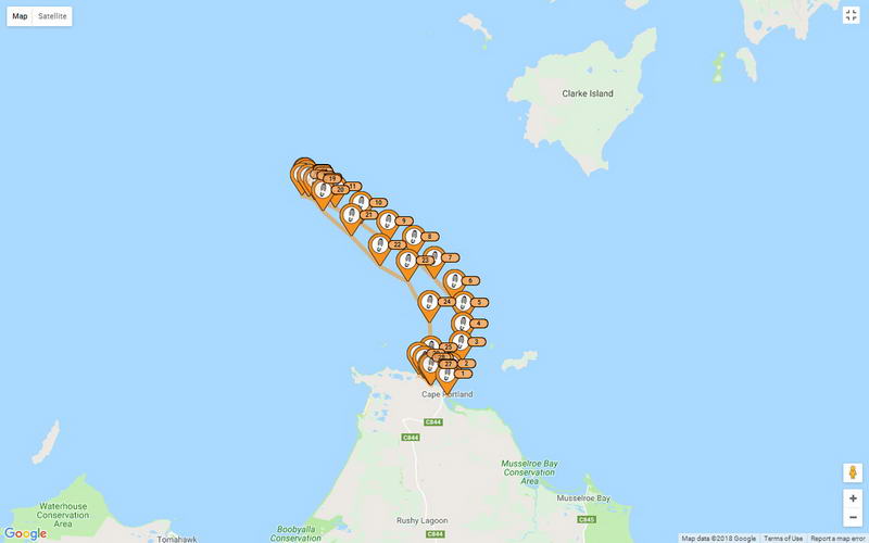

This
quite plainly showed my track onshore, walking to check
out the beaches. Why would anyone consider calling the police? Spot 27,
before I started walking, was logged at 10.02am, 148.02022, 40.75404.
Sue and I are planning to paddle to Flinders Island about
the same time next year but I have a feeling it might just be the two of us –
I’m not sure anyone will ever want to paddle with me again. Certainly not at
night. Ah well, worse thing happen at sea.
Laurie Ford.
March 30th, 2018.
The Debriefing Trip
Toby
rang up a few days after I was home saying he wanted to come down and
go for a paddle somewhere. We decided on Maria Island for 2 or 3 days -
and John and Mac decided to come as well. We paddled over to Maria
Island on a sunny calm cloudless day and sat around in the campsite in
Chinamans Bay having lunch together. We talked about our night paddle
and could laugh and joke about it, which was good to see. I told them I was proud of the way they had extracted themselves from an awkward situation.
But
we couldn't understand why the Victorians were so slow getting back -
they were much younger and fitter than us seniors. They were landing at
Little Musselroe Bay about the same time I was landing less than a
kilometre and a half away, but had departed from us at least an hour
and a half before we turned back.
It
should have been so easy for them. When we left Little Musselroe Bay on
Saturday night we paddled magnetic north the whole time and the current
took us way out where it did. Roger and Tom and Georgia left us at
about the change of tide so all they had to do was paddle magnetic
south the whole time and the current running in the opposite direction
would have carried them straight back to Little Musselroe Bay.
I
can only think that they may have used their GPSs to navigate with and
that would have been a big error if they plotted a course straight back
to Little Musselroe Bay from where they were. IF
they did that then they would not have got within a bull's roar of Cape
Portland but would have been swept straight past out towards the Tasman
Sea heading for New Zealand. Then they would have had a real battle to
get back towards Little Musselroe Bay and would not have been able to
do so till the current started to slack off a bit. That is only my
surmise of how they could have been so slow and how we caught up at
least an hour and a half. Note
added on 19th April, 2018. Our track is clearly shown on this page but
Roger refuses to make his map available. I know that GPSs will
give maps like this but Roger won't let me see his.
Mac
and Toby and John went off for a walk around to the neck joining the
two halves of Maria Island, and over to Riedle Bay on the east side.
The
next day Mac and Toby circumnavigated South Maria Island in an
anti-clockwise direction in empty kayaks and carried them back across
the neck. They had a one hour lunch stop in Haunted Bay - the whole
trip taking about 6 hours including the lunch stop. I saw them launch
after the portage and flashed my strobe light at them - they saw it
quite brightly shortly after launching. This was over 2km away on a
sunny day.
The
next day we did plan to paddle up to Darlington, and then back to the
cars the next day but the forecast was for a bit of rain and the camp
ground at Darlington is fairly poor so we came home a day early.
I
was glad that Toby came down for a paddle because otherwise we would
not have all got together to talk about the night paddle. Incedentally
Toby and I slept under separate tent flys at Chinamans Bay and during
the last night Toby found a Wombat snuggling up against his sleeping
bag - out of the rain. Return to Home page.