GPS’s are deluding
people
After reading some recent trip reports of people paddling
across Banks Strait I feel I absolutely must point out that their GPS
is
deluding them. They don’t seem to understand what a GPS is telling
them.
First I would
like to define some terminology. If I read a
kayak trip report and I read that last Thursday they had a 30km day,
and on
Friday they had a 15km day, and yesterday they had a 50km day then I
automatically assume that on Thursday they paddled 30km, and on Friday
they
paddled 15km, and yesterday they paddled 50km. I really can’t see any
other way
of interpreting their trip report.
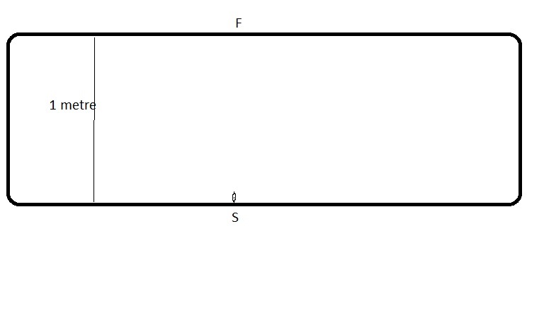
Now let’s say we have an ordinary household bath tub that is exactly one metre wide. Let’s say we have a miniature kayak with a miniature man and he has a miniature GPS. He is going to paddle across from one side of the bath tub to the other – a distance of one metre. As drawn below:
Let us now look at a much bigger bathtub – the Banks Strait bathtub.
These are
direct quotes from the trip report I was directed
to:
"we set our sights on
making a start and paddling 6 km to Swan Island
for the night so as to set ourselves up for a small weather window to
make the
rest of the crossing to Clark Island in the
morning.……….. At 5pm we launched
and quickly made the 6 km crossing by 6pm and set up camp on the beach
on the
western side of the
island…………………….
Next day was an early start up in the dark
at 4.45am and on the water by 5.45. Winds were 8 knot NE and predicted
to
increase to 20 knots by 11am. This was a head wind so we were keen to
go as
early as possible but still had to take into account the tides. They
run at up
to 3 knots in an east/west direction through Banks Strait. Banks Strait
has an
awesome reputation for rough water with wind against sea. With an
ebbing tide
it was certainly a lively bit of water. The predicted tide change was
for 7am
but as became the norm for the area the change was an hour and a half
late and
we were drifted over 4 km off course before the change brought us back
on
course for the SW tip of Clark Island."
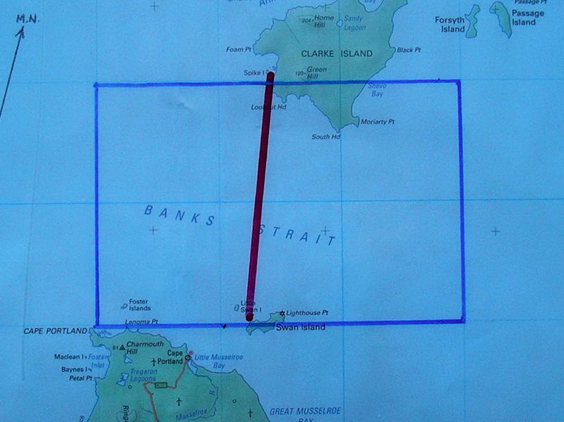
From Swan
Island to Spike Bay across Banks Strait is close
to 21km – the red line (this map has a 10km grid). But Banks Strait is
like a
huge bath tub (outlined in blue), that whole body of water moves
sideways and
back again exactly like the bath tub that was carried sideways above.
Say you
start paddling 2 hours before LW. The next two hours all that water
will move to
the right say 4km, then at LW it will change and all that water will
move back to the left
4km. This is exactly the same as the bath tub being picked up and
carried
sideways and back again. When you get ashore at Spike Bay your GPS is
now going
to show that you have travelled say 28km – but for the same reason the
man in
the bath tub cannot count the 30 metres he was carried sideways in each
direction, you cannot count the 4km you have been carried in each
direction in
Banks Strait. To quote the trip report again:
we were drifted over 4 km off course before the
change brought us back
on course
When the trip
report is written it should say that they had
a 20km day – the GPS reading minus the 4+4 km of sideways movement, ie.
20km. If
you write a trip report and say you had a 28km day then really you
don’t have any idea
of what the GPS is telling you in this situation.
This is just
simple mathematics and if you can’t understand
it then print out this article and take it to your local Primary School
and get
the Mathematics teacher to explain it to you.