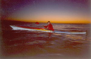
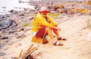
 Before
sunrise in Banks Strait.
Before
sunrise in Banks Strait.
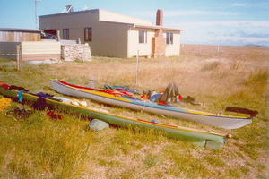
Both our departure from Little Musselroe and our return there two weeks later took place in darkness which made my grand Banks Strait paddling adventure perfect! Being out at sea in the dark! What an experience for an American Grandmother used to day paddles on lakes in New Hampshire
Before
sunrise in Banks Strait.
It was amusing to hear that some would-be sea kayakers had spent quite a few days on Swan Island, attempting to paddle across to Flinders Island. They apparently returned to the flat water of Lake Burley Griffin without tackling Banks Strait.
SATURDAY: We were on the water at 4:50 AM on the
flood tide with no wind. Laurie was in his home built, 20 year old “longboat”
and I was paddling my Greenlander 3, purchased last July from Penguin Fibreglass.
Leaving the bay’s inlet a surf wave completely flooded my face and spray
skirt and then we were in calm water. I watched undulating bands of
luminous phosphorescence in my bow wave and around my paddle spots. The
water and sky were inky black before the first beginning of light and the
hour long period of dawn before the sun finally was up. Mutton birds flew
near us in the earliest light.
We were four hours twenty-five minutes crossing
to Spike Bay on Clarke Island. There hadn't been enough wind for sailing
so it was just a steady paddle. Our plan was to walk and rest and wait
out the six hours of ebb tide before moving on. It was a beautiful blue
sky day.
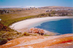 Kayaks at Spike Bay on Clarke Island.
A couple of young lads were camped over in the next small cove, and
were going out diving in the launch belonging to the island, a 4WD vehicle
was there for a good bit of the day.
We walked along a rough 4 wheel-drive track
across open tussocky grass land to the crescent beach at Rebecca Bay, swam
there, and then went up to the top of Lookout hill to see back across the
Strait. By 3:30 a strong westerly wind was howling across the island and
back at Spike Bay we began looking for a good tent spot, in case we couldn't
continue on as planned to Preservation Island. There were 2 small A frame
sheds nearby, one with a side completely missing, and the other with door
and window missing. We decided that in an emergency we could use this one,
and went to some lengths to clean the dirt and bird droppings out of it.
Had a nice beach fire. Near 6:00 the wind seemed to be abating and we set
off. But even before clearing the bay we realised that the sea was too
angry, we could see a rainstorm approaching, and the wind was too strong
for me. Deciding to return to the beach I needed Laurie's help to turn
my boat and he put the tow rope on to help me back. It was a hilarious
moment when we realised the locals had dragged the A frame hut down to
the next cove for the lads to camp in, as it was very obvious that a gale,
and a lot of rain, was imminent. We pitched our tent under brushy shrubs
with storm guys to hold it in the gusting wild wind. App. 25k today.
SUNDAY: Listened to the 6:35AM weather on the radio - gale warnings, winds southeasterly. A good chance for us to go on to Preservation Island. On the water at 7:00 for a great ride with big following waves. A few heart stoppers but totally exhilarating!
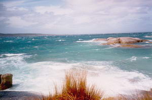 Seas off Preservation Island.
Two hours later came into the shelter of the cove by the shack on Preservation Island, hauled the boats up onto the grass, and changed in to dry clothes, jackets and wool hats to walk to the eastern end of the island to see the site of the Sydney Cove wreck. The Sydney Cove was deliberately run aground there in 1797 after a voyage from Calcutta which had been fraught with storms and leaks. The cargo of rum was off loaded to the adjacent small island and the men and supplies set up camp in the shelter of enormous rocks, using the sails for shade and to collect water. A longboat set off for help (landed in Victoria) and three of the seventeen men eventually walked to Sydney. The rescue of the Sydney Cove marks the start of the understanding that these waters were a navigable Strait which would eliminate the dangerous voyage around the bottom of Tasmania. There's a framed copy of the captain's letter in the shack where we spent the night, dry, comfortable and warm. App. 10k today.
MONDAY: The 5:55 weather report gave continuing gale warnings
but the sun was out, the sea flatter and the wind not so wild. By 8:45
we were on our way toward Cape Barren Island, with front sails up in a
strong southeasterly wind. (Sometimes I was quite out of control screaming
down across a wave ... at one point almost rammed Laurie but he fended
me off.) Past Thunder and Lightning Bay and then up around Cape Sir John
in lighter wind. Through the channel by Long Island and then around the
jetty and into the beach at The Corner, the tiny town on Cape Barren Island.
There are new brick buildings there now for
the Post Office, medical center, and the grocery store/cafe. We had meat
pies and banana popsicles! The next day the store would be closed for the
stocking of shelves with goods brought by the once-a-month delivery boat.
Just up the dirt street was a war memorial surrounded by a white picket
fence and shaded by a huge macrocarpa tree, and just past that the small
school house with playground equipment. Two tall wind generators made a
whooshing noise at the end of town. Soon back to our boats and on to Ned's
Point where the big old macrocarpa trees told that an English farmer had
settled in that spot and that there would be a flat area for camping. We
set up camp and I took a walk out onto the big boulders of the point where
orange algae on them looks like spilled paint From the point I looked
across at big Mt Strzelecki, which we would be climbing one day soon! There
was lots of dry wood around, including branches with dozens of pine cones
in clusters, so had a cheery big fire all evening. App. 20k today.
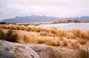 Mt Strzelecki from Neds' Point.
TUESDAY: Southerly winds forecast so we got on the water at 8:45 and paddled eastward all along the north shore of Cape Barren Island, following in and out of coves on a flood tide with almost no wind. I did get to use both sails for a short while in easy conditions to get used to the rear sail. I named our lunch stop Cormorant Bay because I had approached closer and closer Indian style to a preening cormorant (who actually seemed to care less about me). We were eye ball to eye ball when he finally flew off.
 Lunch time at Cormorant Bay.
By the time we got to the passage out to the Farsund wreck the tide was ebbing and we only stayed alongside for a moment. The Farsund is an Norwegian ship wrecked there in 1912 on a sand bar while en route from Buenos Aires to Sydney. Big breakers and confused water surge along the beach of Vansittart Island right there as well as in the distance where shallow sand bars make extremely turbulent areas.
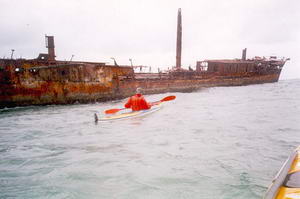 Elli alongside the Farsund.
We paddled along the northeast side of Vansittart Island till we spotted an area of she-oak trees where Laurie had camped last year. A good sheltered spot way behind the dunes. We changed into dry clothes and walked to the cairn at the top of the hill, past a few scared cattle who ran off at a gallop, and many pairs of Cape Barren geese which flew up out of the clumpy long grasses. Saw views of the eastern side of Cape Barren Island and of Flinders Island, of the Farsund far below, back along Franklin Sound and across to Lady Barron town. This had been a grey day with some mist and was just right for a long paddle with little sailing. In the dusk Laurie saw at least fifty Cape Barren geese standing in pairs on the beach. App. 31.6k today.
WEDNESDAY: On the water at 7:10 after seeing thousands of mutton
birds flying by our beach, skimming the water, in the earliest light. We
estimated that fifty were passing our spot each second and that the mass
of them went on far longer than the 30 minutes we were watching. They were
heading east, out to sea.
Out across rambunctious water (standing waves) at
the edge of submerged sand banks and sailed in a mild easterly wind on
flood tide over to Lady Barron, taking an hour to reach the pier there.
A boat had recently off-loaded lumber, roof trusses, a radio antenna in
big sections, cattle chutes, guttering, etc which lay at the side of the
road. Later we saw a flatbed semi-truck loaded with all those items heading
for the island's main town of Whitemark. (The bay at Whitemark is too shallow
for such boat landings).
We changed and walked through the tiny town
to Vinegar Hill for the view up the eastern coastline with its lagoons
and endless long beaches. Stopped in at the grocery store/post office to
write some postcards home and saw that the only pub/motel in town has been
closed down. Spoke with the owner of a catamaran down from Eden, NSW, who
has been waiting for days for gales to end and favourable winds for the
homeward trip. It pays to be in a kayak with no set plans! Back in our
boats, front sails up, and paddle/sailed all the way along the south shoreline
of Flinders to Trousers Point campground. The last hour the tide changed
to oppose us and there was little wind.
We set our tent right near the top of the
wooden steps leading from this beautiful small cove beach up to the picnic
tables and facilities of the National Park area. Soon we were joined by
a group with several tents who had flown over from Melbourne for some quiet
days of camping and fishing. We read and relaxed by a fire. App.
37k today.
THURSDAY: No paddling today but a good climb up Strzelecki Mountain. A kindly couple gave us a lift, letting us sit on the tool chest in the back of their ute, as far as the start of the hiking track (about 6k from the campground). Once we reached the top, at the double headed peak, clouds were swirling up from the east and covering the very top so that we only occasionally could get a sneak view. Very windy and very cold! Once back down below the cloud we sat to enjoy the warmth and the view out over to Chappell and Badger Islands and the turquoise water of Fotheringate Bay right below us. Amazing to think of the Three Peaks racers who will be running from Lady Barron up Strzelecki and back (66k) this Easter!
FRIDAY: Another shoreside day as the same people took us and their push bikes (for us to use) into Whitemark where we spent the morning looking around and enjoying the bakery before riding back the 15k from town with the strong easterly wind at our backs. I couldn't remember the last time I'd ridden a bike but soon was feeling like a teenager again. The easterly wind picked up in strength all through the day and blew fiercely at night.
SATURDAY: On the water at 9:20 after taking a quick walk on the big rocks to the point to have a look north. We retied my rudder straps which had loosened and made the rudder quite worthless coming up from Lady Barron. One needs rudders for happy sailing! Once round the point we were into a strong northwesterly head wind. An hour and fifteen minutes hard paddling through marvellous rollers to Big Green Island where we took a fifteen minute break to walk up to the shack there. Then paddled another hour towards Isabella Island with me finding it hard going. Instead of bucking the wind for another two hours to get past Long Point we turned and sailed to Whitemark, landing at the park by the beach just south of the town pier. The park offers changing areas and toilets. A great decision as we were soon changed and sitting at the bakery for salad rolls, meat pies, and chocolate eclairs, washed down with bottles of Bundaburg ginger beer.
 Elli running before the wind into Whitemark.
We visited Dawn's Furneaux Gallery and purchased one of her exquisite watercolours of Strzelecki from Trousers Point, to be mailed home for me. Her art gallery is hidden on a back street, surrounded by flowers, and filled with her paintings, and jewellery and clothes by other artists, as well as cards and photos of the islands. Later we went to the pub at the elderly Flinders Interstate Hotel to have Mercury light ciders and a roast pork dinner. This trip was becoming most civilised! App. 15k today.
SUNDAY: On the water at 9:00 and headed to Long Point.
One hour with gentle westerly headwind to get there, and enough water to
get over or miss the hundreds of sharp pointy rocks waiting just below
the water to do damage to an unsuspecting kayak. Coming up Arthur Bay we
got out to stretch at Blue Rocks and then continued on to Lillie's Beach
to pull up among the masses of sea grass on the beach and have a quick
lunch at the picnic table above the old pier pilings.
Coming around Settlement Point I had my first
dowsing. We cut through a rocky area inside of the point. I love ducking
in and among rocks and estimating space and water. But this time I missed
and found my boat resting on a rock just before another wave came through,
spilling me out. Laurie came along side, I was back in with my boat pumping
out, and then we headed out to round the point instead. Large multi-directional
waves frothing all around out there! “Paddle Hard” he yelled as the tide
was trying to send me backwards. Of course, it all takes less time to do
than tell, and we were again on our way, sailing on towards Allports Beach
and Emita.
 Allports Beach
Dr Allport had a surgery in a small house which still stands above the beach/park area. It's now “Polly's house” according to locals. We carried our things to the Doctor's tennis court which we correctly guessed to have been used in the 1920s. Sheoak trees grow up in it now but the flat surface is excellent for camping, complete with picnic table and fire ring. What a place - the perfect small cove with white sand and sparkling water just gorgeous on a blue sunny day. App. 26k today.
MONDAY: A lazy day on land. Two volunteers were at the Emita
Historical Museum cataloguing so said we could see it all, even though
the hours were really 1-4. Several rooms of displays, ship wreck articles,
photos of settlers and aboriginals, and a mutton bird shed exhibit. There
are albums of information about every subject imaginable. We looked up
Dr Allport in the album marked “Doctors”. We walked about 14k by way of
the Wybalena chapel and cemetery (a grave of the first white male born
on Flinders who died at age 11), out to Settlement Point and back along
the rocks to a mutton bird information and viewing platform by Port Davies.
Everyone on Flinders is talking of the cruise
ship which will be bringing tourists to the Island tomorrow. The first!
It carries 120 passengers and 76 crew but is only half full. It is “pricey”
with customers paying A$31,000 to A$42,000 for a ten day trip of the remoter
parts of Tasmania. It will disembark people here at Port Davies in the
morning. Each day's end I enjoy leaning my mat against a tree and reading
in the complete quiet of our campsites.
TUESDAY: Up and on the water at 8:00. Around the point of Allports and there was the cruise ship, the Clipper Odyssey,
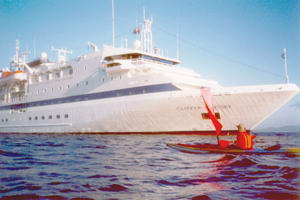 The 'Clipper Odyssey'
resplendently white and sleek. Four small rubber boats were taking passengers to the sloping rock which makes the landing place on shore. We had our hot pink front sails up and sailed right up to the stern of the ship where the unloading process was going on. We took photos of them and they took some of us. Then we waved and were off around Settlement Point and into an easterly head wind all the way to Blue Rocks where we came ashore to let the tide turn and the great shallow areas of Whitemark's Bay fill up more. As we watched, the Clipper Odyssey came around Settlement Point. (Later we heard that the easterly was dragging the anchors and the captain had to find better holding ground). Soon we were rounding Long Point and then bucking that same hard wind all the way in to town. At one point Laurie spotted a young black swan and we both came along side it, cornering it, while we picked it up and put it on my deck for a closer look. He was absolutely relaxed, not trying to snap or leave. I felt his soft feathers and looked in his eye and then let him go. We landed back at the town park at 2:35, quite tired.
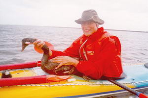 Elli with a captured black swan.
We had a fun evening at the Pub talking with people who had been selling local products to the tourists but who were disappointed. After all the preparations, sprucing up, laying on extra staff, etc the tourists barely bought or spent anything. Apparently they had been told it would be a flora, fauna and history tour day. Later, in the tent, we turned on the radio and happened to hear a phone interview with one of the three bus drivers of the day, saying that there had been concern all day about the reloading (which did take place again at the rock at Port Davies). App. 26k today.
WEDNESDAY: Up and on the water at 6:30. Light northeasterly for sailing to the point, then strong northeasterly to sail across to Trousers Point where we stopped so that I could again fix my rudder straps. This time Laurie got out his trusty sewing kit and stitched them once and for all. Then light wind, no wind, and light wind again as we sailed and paddled across to The Corner, and through the passage by Long Island. Here I got to thoroughly enjoy two sails with my boat zipping along, the prow often well underwater. What a blast! Just as we came into Thunder and Lightning Bay we dropped the sails and paddled hard into the northerly wind to the beach. App. 43k today.
 Running 'goose-winged near 'The Corner'.
Carried the boats to the highest edge of the beach way up in the long grass and took our gear to the camping grove under the tea-trees. Perfect sheltered place for the next three nights as more gales came through and the sea churned angrily out at the far side of the bay with waves exploding on the rocks way out there. Each day we walked the 12k round trip to The Corner, having meat pies, Bundaberg ginger beers, and reading out-of-date newspapers.
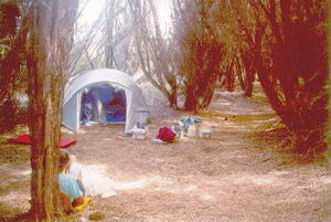 Very sheltered campsite at Thunder & Lightning Bay.
On the beach we found several places where fresh water bubbles up out of the ground, and cleared the seaweed out from one of these and built a small dam of rocks, making a perfect little pool to wash in each day.
SATURDAY: The wind was down so on the water at 7:00, sails up and on our way to Preservation Island. Big waves around the point, going through by Key Island. To Preservation in one hour fifteen where we pulled the boats up and lazed around during the day. Much too big an ocean in the Strait still to cross. I walked to the western end of the island and we sat down in the center of a curious and friendly crowd of heifers while they stretched their necks as long as possible to lick us.
 Waiting for wind and tide on Preservation Island.
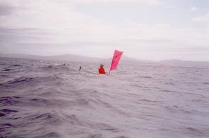
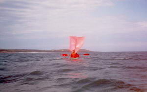
At about 6:00pm the wind had turned the windsock on the grass airstrip from westerly to norwesterly, there were no more whitecaps to be seen way out in the Strait, and the air felt milder. We decided that this was the moment. The tide was at full. We were underway in ten minutes and soon were enjoying mountainous swells - when they are not breaking the bigger the better! Two sails up in slight wind all the way across. At 8:00pm the sun set as a great ball into the waves. Lingering evening light and peach and mauve colours. Then the half moon began shimmering on to the waves. Just on dark the sea had settled and there were no more swells. We watched Swan Island light and the “loom” of Eddystone Light. We saw the lights from squid boats out further to the east. And an occasional bright light on the distant shore ahead. We could see each other easily in the moonlight.
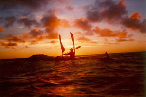 Exactly halfway across Banks Strait as the sun set.
We headed magnetic south by our compasses and were taken just right
by the tide to end up at Little Musselroe where we could see the inlet
through the beach. Laurie had mentioned that as soon as we lost sight of
the lighthouse on Swan Island we would be entering an ‘obscured sector'
and must be at Little Musselroe bay. Tide was at its prime pouring out
and while Laurie went in fine I had trouble pulling against it and got
out to pull my boat around into the bay, (my second dowsing) got back in
and paddled a dozen strokes across to the boat ramp. It was 10:40pm. This
had been a glorious day of app. 42k. We put the tent up right
there on the grass and next morning talked with Liz Ponting in the
end house and signed her paddlers book. I think I may be the oldest woman
to paddle across Banks Strait - at 63 - I'm certain I'm the oldest American
woman to do it! Now that's fun.