Typical island scenery in this area.
So we had a couple of days before the funeral and decided on an overnight shakedown cruise on Lake Winnipesauke, a lake about 22 miles long and about 10 miles wide. It has a myriad of islands on it, the majority privately owned, with large summer homes built on them. So late one afternoon we set off from Wolfeboro and crossed to the other side of the lake and camped on an island not far from a place called Weirs Beach., and had a very pleasant night there. The next morning we left early and called into Fay's Boatyard to see if the cleats I had ordered had turned up - but no luck. Then it was back to Wolfeboro, with only a couple of very small modifications being found necessary to make.
Three days later, after a three day drive to Ohio and back, we were ready for the 3 1/2 hour drive to Castine, Maine.
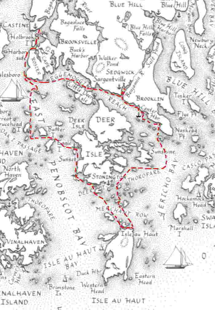
Why Castine? Well originally we had been figuring on starting here and paddling down to Stonington, out to Isle au Haut, round to Bar Harbour, up through the narrows, and back through Eggemoggin Reach to Castine. Now we really didn't have time to do all that, so would leave out the Mount Desert Island bit. We were fortunate to have friends in Castine where we could leave the car a couple of houses away from the main wharf area. This was an old 1770 house, still on its original granite foundations.
Typical island scenery in this area.
Monday:
It was a clear blue sky day, and had just gone high water as we left
the boat ramp and headed into a 10knot SW wind, across the harbour and
down the inside of Nautilus and Holbrook islands. Along the
side
of Cape Rosier we saw an Osprey, and its huge untidy nest of sticks on
top of a tree close to the waters edge.. We stopped to watch
a crab
boat hauling in its traps and taking the crabs out.
This is also the area where there seem to be dozens of old ketches, schooners, two masted and three masted - all vying for the tourist trade. There were at least four in sight as we headed for Pond Island to camp for the night. This island is very flat, with a pond in the middle that fills with water every high tide. The camping was not the sort of place I would choose to wait out a storm for a few days, and the island so small that you walk around it in well under an hour. Back home in Tasmania we normally camp above squeaky white beaches a mile or so long, with hills and mountains nearby to climb. This Maine coast area was a bit of a shock as far as camping goes, but the island scenery was quite beautiful.
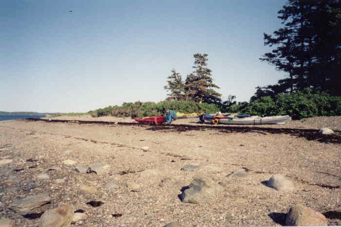
Pond Island shoreline at low tide.
We gathered up a quantity of driftwood for a fire below the high water mark. Because of the deciduous trees the humus on the island must be feet deep, and any campfire there would probably burn for weeks or months. The next morning there was not a trace of the fire, wiped away by the incoming tide.
Tuesday:
Breakfast on the shoreline was spent watching a pair of loons close
by, as well as the many seagulls. We carried the fully loaded kayaks
down
the pebbly sea weedy shoreline to the water - it was low
tide. Then
it was off south to paddle across to Beach Island, Great Spruce Head
Island,
Barred Islands, and Eagle Island. There were several harbour seals on
rocks
that were about to be covered by the rising tide, and there was also a
small ferry visiting one island after another. Passing below Eagle
Island
Lighthouse we headed across to Sheepshead Island, and found that there
was a very fast current flowing north through the channel. The many
lobster
pot buoys had their own wake streaming behind them, and were lying flat
on the water. Our course was semi circular as we battled across to the
island, finally finding the current slackening off as we neared shallow
water.
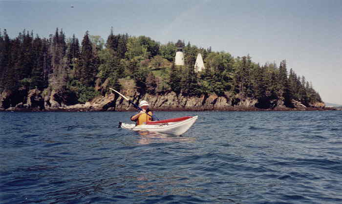
Eagle Island Lighthouse.
We took an hours break on a small pebbly beach while waiting for the tide to abate somewhat, then continued down the coast of Deer Isle towards Stonington. Off Stinson Point we passed between the shore and another Barred Island (there are many islands with the same name here - three Sheep Islands at least). On Barred Island there was a huge eagles nest at the top of a tree by the shoreline, and a couple of trees away a bald eagle was sitting right above us. It didn't move as we paddled past, so the couple of people on the main shore with huge telephoto lens on their cameras could still watch it after we paddled round the next point.
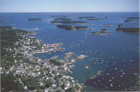
Elli had relatives that owned property near Stonington, so we went ashore and camped there, and walked the couple of miles into Stonington. Here we found the museum was closed for the day, the market was closed permanently, but we found an ice cream place open. Stonington is a very tiny place with very few facilities for the passing kayaker, although tourists in cars would find B&B's and other accommodation. At a very nice bookshop/store on the waterfront we purchased post cards and other small items, before walking back to camp. At dusk we had our usual fire below the high water mark, under a clear bright starlit sky. The foghorn on nearby Mark Island goes 24 hours a day.
Wednesday:
We were on the water by 5.50 am, to beat the low tide, when the
entrance
to the small bay we were in would be closed off by rocks. Two days of
light
SW winds was now changing to stronger SW winds, as we headed south
again
past Crotch Island, Wreck Island, to Merchant Island. It was now quite
blustery as we battled across to Isle au Haut. Being so early in the
morning
it didn't seem worthwhile going into the small village, and was too
cold
to spend much time out of the kayaks. Instead we decided to keep Isle
au
Haut for another trip, and about turned to head for the wooden boat
school
in Eggemoggin Reach.
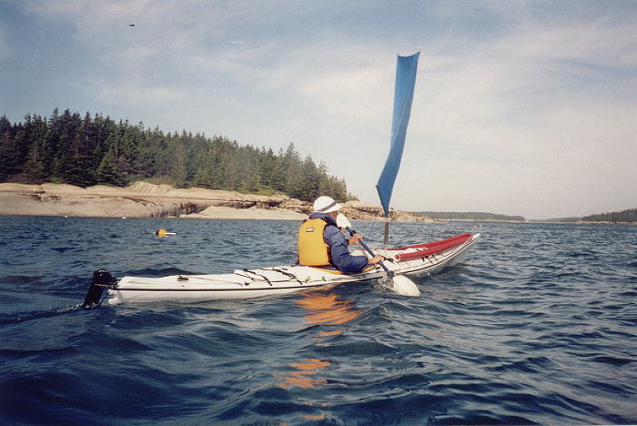
Elli near Merchant Island.
This meant we could finally have a good sail. We'd had the sails up for brief periods the past two days, but now the weather was what they had been fitted for. The two mile open crossing to McGlathery Island was sheer delight, and was strong enough to keep us down to one sail each. Then we were back in amongst the islands where the wind became more gusty and unpredictable. At Hells Half Acre (very aptly named) a camper was just launching to go across to Russ island, less than a mile away. He was rowing a dory, and we wondered how he avoided the many rocks, because he had his back to the direction of travel.
Elli and I continued along the coast in a NW direction, to one
of the
many Sheep Islands. We went ashore briefly to change a film in the
camera,
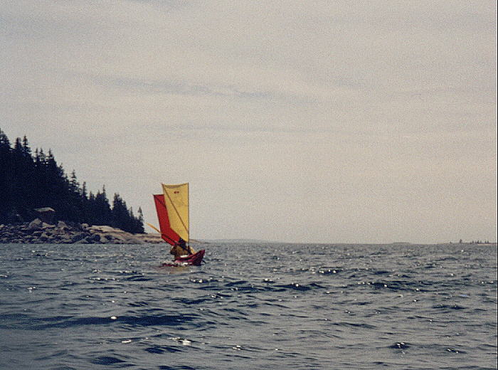
then went on our way again. I could see a ketch leaving Eggemoggin
Reach
so decided to head out to sea to get close to it, putting up both sails
in the still fresh SW wind. This was fun, and eventually I closed to
within
a few feet of the ketch as it tacked towards me. The tourists
had
a good opportunity to photograph my ketch rigged sea kayak, as I
photographed
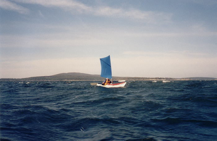
them, somewhat smaller than the monster they were travelling in. Elli
was
still inshore, but her sky blue sail made her easy to spot as we
converged
again, and headed into the reach.
 |
 |
 |
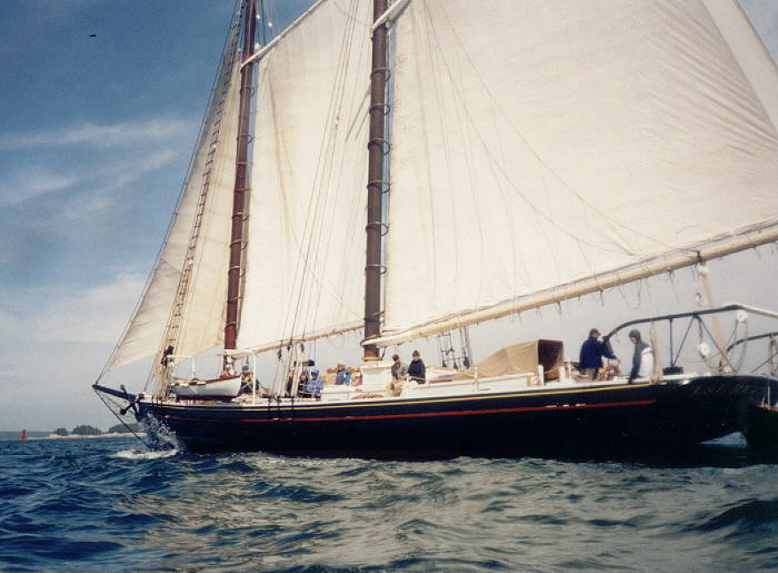
| Schooner. | Schooner. | Ketch. |
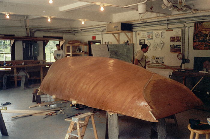
Near the Wooden Boat School a small sailboat was sailing about, and just mooring as we arrived. We changed into dry clothes and wandered up to the school, checking out the shop before going on to the workshop. Several classes were there - one building stitch and glue sea kayaks, the other working on a cold-moulded 20 footer yacht. We wandered in and out of various building, where various old wooden boats were in stages of rehabilitation. Having once worked for a boat builder (Jock Muir - Tasmania) I was very interested in seeing all this - it took me back to my teenage years. The classes broke for lunch while we were there, and one of the instructors said he'd just heard that we just came in under sail. Being a kayaker himself he wanted to see our rigs, so we went back down to the boat ramp to show him. He had tried some sort of sail before, but apparently it was not easy to use, and you couldn't paddle while it was up. He seemed to like the simplicity of our sails, and may one day try them out. We were carrying a couple of videos of Tasmanian Sea Kayaking, so presented him with a copy - these show kayaks sailing in 30 knot winds, and big seas.
While sitting out of the wind, eating lunch, one of the sea kayak instructors and his wife also checked out the kayaks, and gave us lots of good information on local camp sites. We did know about the MITA camp sites, but they all looked pretty uninviting after what we were accustomed to back in Tasmania. MITA is the Maine Island Trail Association - and seem to be a self appointed group of greenies who have organized islands (private and government) where camping is allowed.
Leaving the school we travelled to one of the places recommended by the locals, and found it ideal. It came on to rain and forced us to put our big shelter fly up, and prevented us having a fire. It rained most of the night, but fortunately stopped just as we were getting ready to pack up.
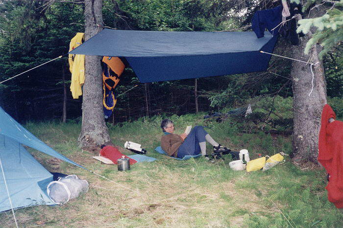
A great campsite, even if it was raining.
Thursday:
We had been thinking of travelling through the reach and back to Pond
Island for the night, but in view of the thunderstorm and NE forecast,
we thought it may be advisable to go home a day early. There was thick
fog in the Reach, so we headed north till we hit the shoreline, and
followed
it along - going in to Center Harbour to have a look at all the
pleasure
boats and yachts moored there. Next we paddled up the Benjamin River,
looking
for the yacht Patience B, which we'd been told had sailed out to
Tasmania
and back. She was an older type ketch, but looked a very seaworthy
vessel.
Going back out of the river I pulled alongside a boat towing a floating
landing stage and talked to the skipper. Unfortunately he was going in
the opposite direction to us so after a brief tow hanging on to the
side,
I once again turned NW up the Reach.
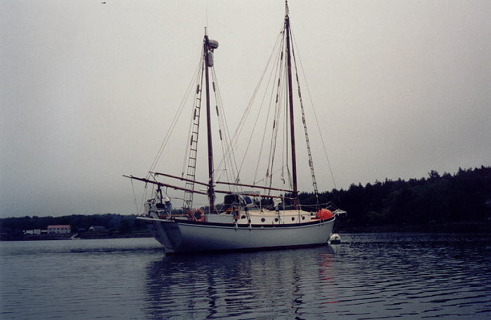
'Patience B', sailed to Tasmania and return.
The bridge joining the mainland is reminiscent of the Golden Gate Bridge, and at the bridge we crossed Eggemoggin Reach to paddle along the southern shoreline - the fog just lifting as we did so. It was now a lovely calm sunny day, almost mirror calm. Pumpkin Island Light is very picturesque, and after taking a couple of photos went ashore at the tiny village of Eggemoggin to put a new film in the camera.
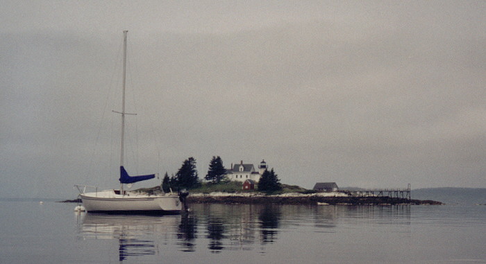
Pumpkin Island.
We spotted two pairs of dolphins as we crossed the mouth of the Reach, and I paddled out to ride in the wake of another tourist vessel - the schooner the American Eagle. This was motoring up to Castine, and was well and truly moored alongside when we got there much later on. There were more sailing ships out off Castine as we arrived, but there was little wind even for their massive sails.
Once ashore we donned dry clothes and went into the restaurant on the wharf for some food and a beer, leaving the sails up in the kayaks to dry out. When we returned a young mother was waiting and wanted to know if one of us was Australian - the Boxing Kangaroo being a dead giveaway. She was from Sydney, Australia, and her american husband had attended the Maritime college at Castine, and was now away at sea.
Most of the sea kayak books written about this area all seem to talk about day trips, and we could see why now. The struggle to get loaded kayaks ashore at low tide, the uninviting campsites (and the obvious crowding at some places) does not lend itself to extended camping. It is also difficult to find overnight parking for vehicles at some launch sites. However, we are planning another longer trip in September next year, hopefully with better weather, and after the summer crowds have gone home.