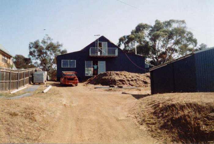
The house we built in 2 months.
Laurie Ford & Elli Tappan.
Another trip to Flinders Island, but this was a bit different. It wasn’t planned, and we didn’t really mean to go. I’d had an email from 10 paddlers from north of Sydney saying they were getting the ferry “Spirit of Tasmania” over to Tassie, then being at Little Musselroe Bay on the 17 March, ready to paddle on the 18th to Flinders Island for 2 weeks - and would Elli and I like to join them.
The house we built in 2 months.
Well. Elli and I were flat out building a house from the ground up, we dug the foundations in January, and were just getting to the plastering/electrical stage. We were loath to leave off building, and in any case we hadn’t paddled since our trip to Flinders Island last year in February - so were not very fit for kayaking. We imagined that if a group were paying big money to come down to Tassie, then they would have been training seriously. We thought that a couple of geriatrics in their mid 60’s would slow them down considerably. But I felt a short break from building would be nice, and said we’d go up to Little Musselroe on the 17th to say hello, and maybe paddle across to Swan Island for a night, before coming home to continue building.
So the 17th saw us at Little Musselroe, but on our own - no sign of other paddlers. A pity, because if I’d been going to go to Flinders Island, I would have paddled over to Swan Island that afternoon, and left there before daylight, and used the tide to get round the western end of Cape Barren Island. The weather was as calm as I’ve ever seen it in Banks Strait. The wind generators at Little Musselroe were stationary. But we camped for the night, and next day prepared to paddle to Swan Island, thinking the others would arrive in a rush ready to go.
Tuesday 18th March.
Come the middle of the day nobody had shown up so we went to Swan
Island,
dead calm day again - the wind generators on Swan Island were
stationary.
We met the caretakers on Swan, who told us there was a gale warning.
Well,
everyone knows that you don’t take too much notice of
forecasts in Tasmania,
they are notoriously inaccurate. One of the unwritten rules of the
Maatsuyker
Canoe Club was that if there was a trip planned, you always turned up
at
the starting point ready to paddle - and THEN we would assess
conditions.
We never sit at home miles away from the paddling area and make
judgements
on the forecasts. And in fact in all the 20 years of doing trips to
Flinders
Island, we just turn up and paddle on the appointed day. And these
trips
are planned 9 months in advance. I can remember my first ever trip
across
Banks Strait was in a 30 knot westerly - the day the Catamaran
championships
at Bridport were cancelled because the wind was too strong. And another
trip Grant was broached sideways down a wave with enough force to snap
his rudder blade off. We don’t necessarily sit around for
days waiting
for a flat calm.
And this trip we didn’t even set the date, people from NSW did.
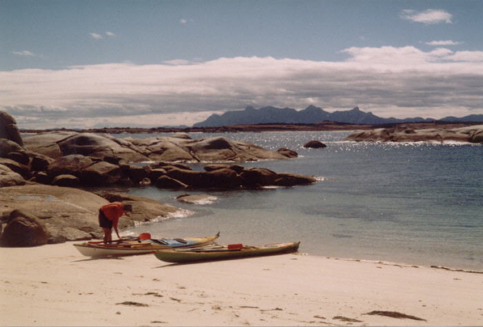
We had landed on Swan Island on the north shore before the lighthouse, about halfway along the airstrip. It was very hot and sunny as we wandered over to the beaches on the southern side, then returned to sit on the beach by our kayaks. Despite the gale warning we had been told about, there was not a sign on the horizon of any bad weather in the next few hours - Banks Strait was still as calm as I’d ever seen it in 20 years. We sat there talking, saying we really should pack it in and get back to house building - this was wasting time.
But I kept looking across at the nearby Clarke Island, and then made the sudden decision to go. The tide was all wrong, we should have gone early this morning, before daylight - but with a bit of luck would make Moriarty Point on Clark Island without too much trouble. We left Swan about 2.30pm and headed on a compass course magnetic north. This takes us at right angles to the current, but would push us way to the east. But as we get level with South Head, and the tide turns the corner and sweeps up round the eastern end of Cape Barren Island, we could then alter course to still paddle at right angles to the current and close with the shore. Hopefully we would still be being pushed north by the last of the current, and then it would change.
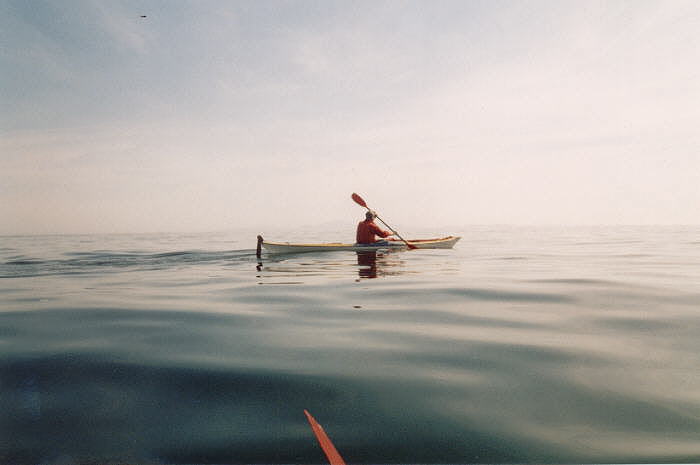
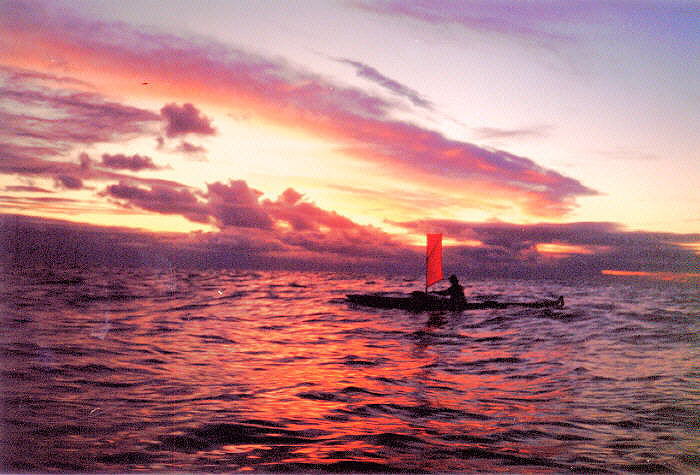
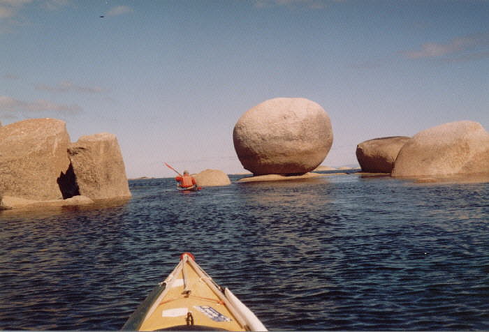
Elli crossing the notorious Banks Strait.
This is exactly what happened, and after two and a half hours we were level with South Head but way out to sea to the east. About now a light NE started up and we could use the sails to make a slight difference. An hour later we were closing with Moriarty Point, and I thought nothing could stop us now - only about 2km to go, and the tide was still taking us north. Just then a very strong northerly blew up directly in our faces - and this was too much for Elli. She had been struggling a bit, and would have just made Moriarty Point under her own steam - but having not paddled for 12 months was taking its toll on her. I offered her a tow into the beach, and while doing so the tide changed and we could see the shoreline slipping past us at an increasing speed. Moriarty was well out of the question now, and I thought that we may be lucky to get ashore near South Head. But we just managed, on the same beach where Rex and John and Jeff and I landed after dark a few years ago. I think Rex got out of his kayak and kissed the beach, he was so glad to be ashore. That trip was done under similar tide conditions very late in the day.
It was dead low water and the beach shelves very steeply, and it was an effort to drag the kayaks up the beach - before hunting for a campsite. We hadn’t found one in the dark last time, but this time had plenty of daylight and found a good sheltered site up in the dunes. It was sheltered from everything except a southerly, but they hadn’t been predicting that. I’d already decided that we’d have all the next day here for Elli to recover fully. Later on that evening while sitting round the campfire the beginning of the predicted gale started - a huge electrical storm was evident over on Tassie. It then crossed overhead and headed for New Zealand, while we watched another one approaching, and another one. It poured all night, and blew and thundered - from the north.
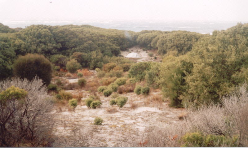
Very sheltered campsite at South Head.
The day was spent gathering huge amounts of driftwood off the beach, and walking round to the Moriarty campsite. We both agreed that where we were camped was far better. It rained on and off all day.
The next morning, after another wild night, the wind veered round to the south, and started popping tent pegs so we made a 2 metre track through the low scrub to a totally sheltered spot - nothing would disturb us in here. The surf built up on the beach, which faces directly south, but it wasn’t so big that we couldn’t have got off at slack water in the middle of the day, or late in the afternoon. However, not knowing any better camp sited further up the coast we opted for another night here. We had collected so much driftwood, strung up a clothesline, etc, it seemed a pity to move. But we did plan for a predawn departure the next morning. During the day we found an easy path through all the scrub and up onto the grazing paddocks above South Head where we had good views up the shore of Clarke Island, and also across to Swan Island. It was still raining on and off, and blowing more NW now. Late in the day we noticed a big flock of terns on the rocks out on a point, and were able to get very close to them before they flew away.
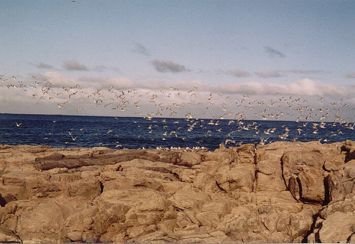
Terns near Moriarty Point.
Friday 21st March.
We packed and launched in the moonlight, and were gliding past Moriarty
Point in perfect conditions as the sun rose. Then as we paddled past
Black
Point the wind started in from the west, and by the time we rounded
Seal
Point at the top of Clarke Island it was fairly hard. But the tide was
flowing fairly hard in a westerly direction, and this helped us decide
where to go. The options were to wait a few hours for the tide to
change,
and then use the wind and tide to scream round the eastern end of Cape
Barren Island (under sail) and up towards the wreck of the Farsund, and
then the township of Lady Barron. We were low on food, as we
hadn’t really
planned to do this in the first place, and we needed a store in the
next
couple of days - probably Tuesday at the very latest.
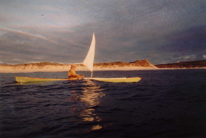
Elli & I at Sunrise.
The other option was to go west through Armstrong Channel, against the wind, but with the strong tide, and try for Thunder and Lightning Bay - from where we could walk to the store on Cape Barren Island. There is a road right along the southern shore on Cape Barren so we could walk from anywhere along here if we had to - but the closer we got to Th & L the shorter the walk would be. There was still a gale warning, had been for the last 3 days, and was for the next couple of days.
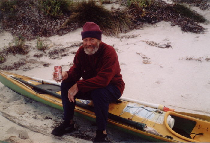
Laurie ashore in Battery Bay
We decided the Armstrong Channel route would be more interesting and offer more shelter, and battled the wind along to Battery Bay. We’d had enough by then, and landed on the first beach we came to and then got into dry clothes and walked right round to the head of the bay. Several creeks flow into the bay, and the one furthest east (at the end of the cliffs) was beautiful water - the others pretty terrible. We found the end of the road at the big stream, and there was plenty of evidence of the locals using this area for camping and gathering firewood. Plenty of sawn firewood still lying around. We went a bit further and found a more private campsite where it would be easier to get the kayaks in and out at low water - then walked back to the kayaks and had a rest, hoping the wind would drop. It didn’t, so later in the day we paddled across to the campsite anyway. It was a perfect spot, and we had our campfire down on the beach and watched the sunset, sipping our port. It was an incredibly peaceful little spot as we watched the moon rise about 9.30pm.
The main creek in Battery Bay, but better water half a km to
the
east.
The big creek nearby has washed plenty of sand down over the years, and it was dry for hundreds of metres in front of it, and only slightly better where we were. We carried the kayaks out to the waters edge before packing our gear into them at dead low water early in the morning. - and then paddled with our blades hitting the bottom for a good way out. We went straight out to the island in the middle of the bay and could then feel and see the tide sweeping to the west. This was great feeling as we cruised along paddling slowly, but watching the shoreline racing by. We had a short break ashore before Key Island, and decided to keep going round Cape Sir John and up to Neds Point to make full use of the tide. There was still a gale warning for today, which was quite a joke - conditions couldn't have been more pleasant. Barely enough breeze to make it worthwhile putting the sails up - but we did anyway. Going round the cape we noticed another kayaker coming towards us, which was a bit unusual because the area is so big it is not often you run into another paddler.
(And despite John Howard's statement that there would be no cloning done in Australia - we suspect there is a secret cloning program going on in Canberra. We kept running into a Mike Snoad in the Banks Strait area, and thought there must have been a dozen Mikes paddling about.)
We naturally enough stopped for a brief chat. Mike had got the ferry across from Victoria to Flinders Island. Some years ago he had paddled with a group from Vic to Flinders Island, but the group ran out of time to complete the crossing to Tasmania, and returned home. Mike was here to finish off that trip, and was heading down to Little Musselroe Bay. He was then planning to spend 3 weeks in the Flinders area before going home to Canberra.
We paddled on, and went ashore in a delightful little cove before "the Corner" - the settlement on Cape Barren Island.
A delightful cove just before reaching "The Corner".
Here we had morning tea, and gave the tide a chance to turn in our direction. Then we paddled past the Corner, and found as we suspected that the store was not open on Saturdays. We still had food for a day or two, so weren't desperate yet - but we were starting to ration it, and the coke. Shortly we were ashore at Neds Point - not out at the end of the point where the road ends - further along in near the huge old macrocarpa trees and pink lillies which indicated where the old farm house used to be. This is another really sheltered spot in any weather. While we sat there some locals went past in a car out to the end of the point, and quite a few kids were soon splashing around - a great little beach.
Disaster struck while we were watching a fantastic sunset over
Stzelecki
Peaks - we ran out of port. We hadn't brought much to start with, not
expecting
to be away this long - but it was imperative we resupply as soon as
possible.
The nearest source was either at Lady Barron or Whitemark, and we
settled
for the latter.
Sunday 22 March
Low tide was about 10.30am, and waiting for it meant the tide would
help us along the shore and north towards Whitemark. But it meant a
longish
walk in really sticky mud to get our kayaks to the water. Because there
were only the two of us it was not possible to carry fully loaded
kayaks
very far, and a long hall like this it was always easier to take them
to
the water half empty, and then load them. There was a SE breeze just
made
for sailing, and we were soon scooting across the shallow water round
Anderson
Islands - detouring round some big dry sand banks that would be covered
with 3 metres of water in 6 hours. There were a few big waves off
Trousers
Point and Elli put in a big support stroke to save herself from a swim.
Then we were past and into more sheltered conditions, and arrived at
Whitemark
about 2.00pm. We always stop just on the south side of town, where
there
is a big green lawn area, and a couple of change rooms and a toilet -
and
a short walk into town. The pub was open and we quickly consumed a pie
each, and a salad roll, and a couple of ciders.
We'd brought our empty port bottle with us for a bit of a laugh, as it has a very interesting label. I showed it to the barmaid and asked if she had any of that brand port. She showed it to the owner, who then took it right round the main bar and showed it to everyone in the pub. They don't have that label, but are planning to get some - we mentioned where we got our bottle from - the Dunalley Pub. We bought a 2 litre cask of port to keep us going. We walked a few steps back towards the kayaks and then thought 'bugger it, why don't we stay in the pub for the night' - so went back and booked a room with ensuite and colour TV. After all, it was the night of the one-day cricket grand final (and the Malaysian Grand Prix). This was a bit of unplanned luxury, but then the whole trip was unplanned. It was great to have a hot shower before walking along to the nearby Golf Club for tea, then back for the cricket. The weather chart seemed to indicate settled weather for the next few days so we planned to re-cross Banks Strait again on Wednesday.
Monday saw a late start (tides and shallow water) and we arrived at Trousers Point campsite late in the afternoon, against a cold SE wind. We were now stocked up with food for a week, and had checked out the pies at the local bakery - still as good as ever. At Trousers we walked up to friend's place - people we had met last year. We had sent them a video of sea kayaking, and they had been inspired to go out and buy sit-on kayaks to paddle around in their area - and really enjoying the experience.
The wind died during the night.
Tuesday 25 March
Got away early, non stop to just past Key Island, where we had a lunch
break. Nice sunny day to laze around for a few hours. Later in the
afternoon
we crossed to Preservation Island and had a good comfortable night
there,
ready for an early start the next morning.
Elli cruising the shoreline near Key Island.
Last year we had got away from here late in the evening, a couple of hours before high water - and arrived at Little Musselroe Bay after 10pm. We would have to get up and be on the water about 3.30am to get the same tide this time, and I wasn't that keen. We left at 6.10am and headed magnetic south. Some hours later as we neared the Tas coast we could see we were being swept backwards by the tide, so turned and headed for Swan Island - aiming to get into the back eddy behind it. We made this nicely, just in time to see another Mike Snoad clone leaving Swan to go across to Clarke and Preservation Islands - a huge coincidence as we hadn't been planning on going to Swan if we could have made Little Musselroe Bay.
Elli nearing Swan Island.
Mike Snoad
After a half hour break on a sunny beach on Swan Island we crossed over to Little Musselroe Bay and dragged our kayaks into the almost dry lagoon to get to the boatramp - dead low tide.
Then on to Bridport for fish and chips, and hear about the Maatsuyker Club 4 week trip down the west coast, from Jeff.
Because of house building we hadn't planned to do any paddling at all this year, but were going to do a 4 week trip to Flinders Island next year - and still plan to. So this had been a very pleasant easy interlude.