| From
'The Sea Canoeist', Vol 3. 1980.
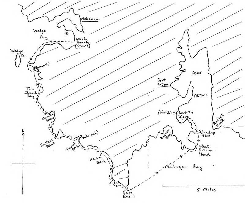
NUBEENA, CAPE RAOUL, SAFETY COVE - May 1979 From Cecily Butorac:
Three of us set out from White Beach on Saturday 10th May in a calm sea with a light following NE breeze. Tony Gaiswinkler and Mike Emery paddled Greenlanders and I was in my trusty old North Sea Tourer. We were three of the five who visited the South Coast and Maatsuyker Island in January. It was an enjoyable start to an exciting trip, surfing along on the light following swells, but Tony reminded us that we’d probably pay for it later on, with a forecast of freshening NE winds to consider. We hadn’t gone too far past Wedge Island when we discovered Mike’s rear compartment was filling with water, so into shore for some plastic tape repairs of several innocent looking but leaky fractures. Whilst busy on the job, Tony suddenly spotted Mike Snook steaming past. We whistled and called him in, and found he’d been running very late, but had seen us disappear round the first point and was determined to catch us. Mike was paddling a ‘Splinter”, which he designed some years ago for down river racing. Until about half way down to Cape Raoul the coast is not spectacular, but after Salters Point it rises in sheer cliffs all the way to the Cape. The strata are at first perpendicular, but suddenly change to horizontal. There are fascinating stepped areas over which the swells break, leaving a cloth of white foam streaming down the steps. We lunched at Tunnel Bay, being the last likely place to be able to land for the rest of the trip. We explored the tunnel which gives the bay its name, and could imagine how spectacular it would be in heavy westerly weather. The coast continues in sheer cliffs down to Cape Raoul, but the horizontal strata suddenly changes again to vertical and the Cape is a towering screen of angular pillars jutting out in defiance of the southerly swells. A pair of abalone divers were busy with their gear as we passed and a little while later they cruised by for a brief chat. They seemed a little surprised at our choice of recreation. As we rounded the Cape the forecast ‘freshening NE winds’ were slamming us in the face and whipping up white caps. Tony and I caught our breaths on a very strong smell and only 50 yards along we found a colony of seals on a very precarious sloping rock. For once they ignored us, usually taking to the water as soon as they see you. It being 2pm we decided to paddle straight across to West Arthur Head, keeping the wind head on. The shore line east of Cape Raoul will have to wait for another day’s trip. It was a solid slog and took a lot longer than we’d hoped. A cruiser found Tony and Mike S. sheltering behind West Arthur Head waiting for Mike E. and me. They came out to see if we were OK and they too were surprised to find we paddle canoes for enjoyment it being obvious to them we can’t clutch a tinnie and paddle too. We were visited in this area by a superb pair of Albatross, gliding low over the sea in graceful sweeps. For once they did take an interested look at us, which gave us a delightfully close view of them. After regrouping, we pushed on around West
Arthur Head where the wind was particularly strong, and for about a
mile progression was very slow, and difficult, until we turned round
Standup Point to run in to Safety Cove, where we’d left
Mike’s vehicle. It was almost dark as the last paddlers
beached, and I was glad I didn’t have to drive back to
Hobart, as I was leading another trip next day on Port Arthur. It had
taken us the same time (3 ½ hours) to cover the 7
½ miles from Cape Raoul as it had to cover the 14
½ miles down to Cape Raoul.
|